In this series I will look at the history of the Forgotten Realms world and publish a series of maps depicting the continent of Faerûn and the wider world of Toril at various points in its past. Like my previous series, Nations of the Forgotten Realms, this series draws on The Forgotten Realms Interactive Atlas and other Dungeons & Dragons resources for the setting, particularly The Grand History of the Realms, Netheril: Empire of Magic, Cormanthyr: Empire of Elves and Lost Empires of Faerûn.
The work of Richard Baker, Ed Bonny, Eric L. Boyd, James Butler, Thomas Costa, Ed Greenwood, Dale “slade” Henson, Brian R. James, George Krashos, Steven Schend and Travis Stout was particularly useful in compiling this series, along, obviously, with the work of everyone who has ever put pen to paper for the Forgotten Realms campaign setting (officially or unofficially).
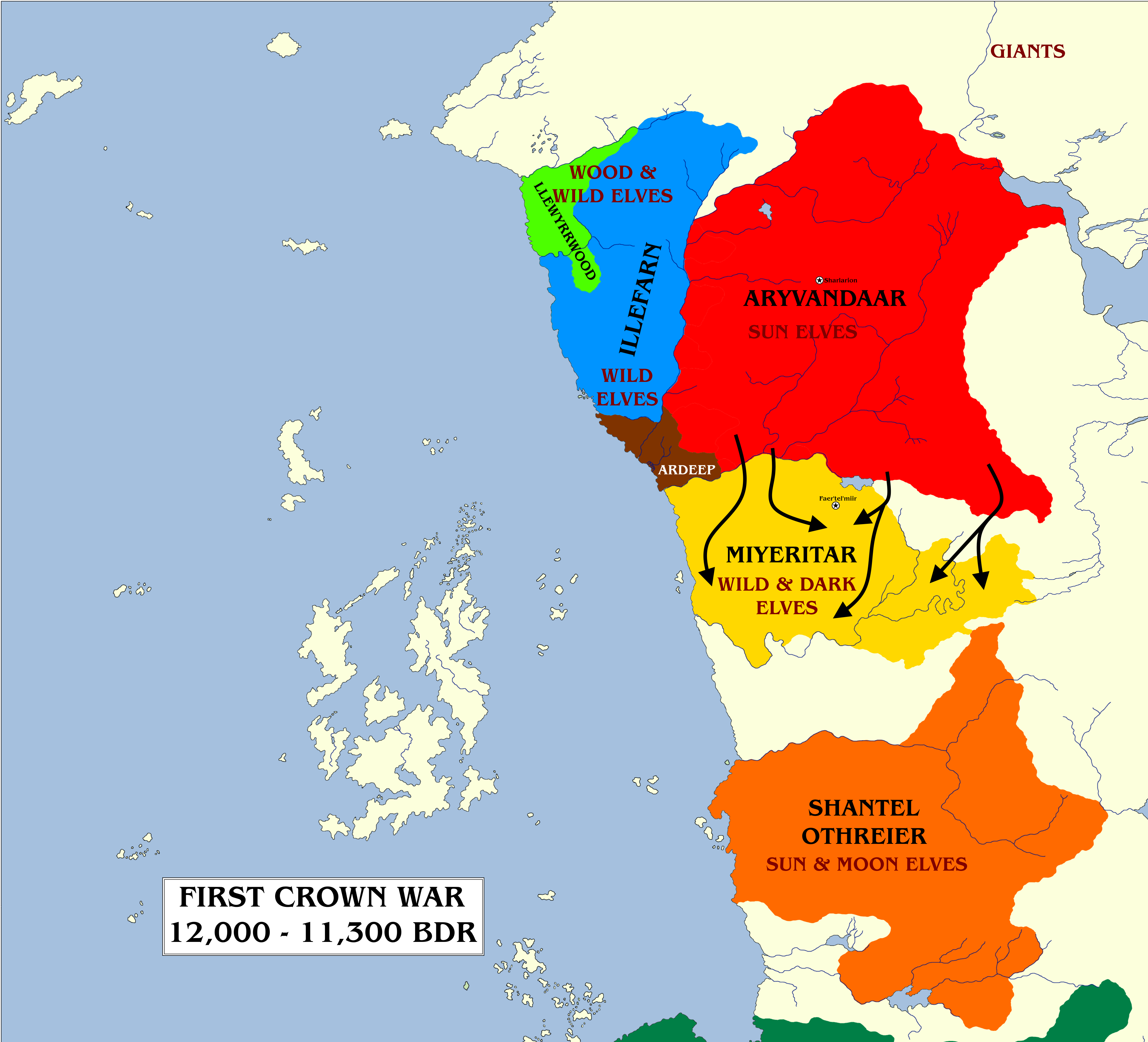
A map showing the elven kingdoms on the eve of the Crown Wars. Please click for a larger version.
The Crown Wars were a lengthy series of conflicts that tore apart elven civilisation on Toril and marked the beginning of the end of elven domination of Faerûn. The conflict raged for three thousand years, beginning circa 12,000 BDR (Before Dalereckoning) and concluding in 9000 BDR, involving almost every major elven power of the day and also drawing in humans and dwarves, amongst others.
As related previously, during the era known as the First Flowering, five great elven empires came into existence stretching down the western coast of Faerûn. There were as follows:
Ilythiir (founded 27,000 BDR): a vast empire of dark elves, descendants of earlier jungle and wood elves who had settled the vast woodlands spreading across much of southern Faerûn. The Ilythiiri forsook the Seldarine to worship the dark gods Vhaeraun and Ghaunadaur before they were fully subsumed into the worship of Lolth, Queen of the Demonweb Pits. The Ilythiiri capital, Atorrnash on the Shining Sea, was destroyed in the Sundering (the creation of Evermeet), cementing their hatred of their elven kindred.
Aryvandaar(23,900 BDR): the vast northern empire of elves, centred on the High Forest with its capital at Sharlarion. Originally home to elves of all kindreds, the sun or gold elves became dominant and increasingly arrogant, elitist and power-hungry, especially the Vyshaan clan (which assumed leadership in 15,300 BDR).
Shantel Othreier (23,600 BDR): a large kingdom of sun and moon elves located in the Wood of Sharp Teeth, in those days much enlarged and merged with the Snakewood of modern Amn.
Ardeep (c. 23,400 BDR): a colony of Shantel Othreier, founded by the latter in the forest lands around the mouth of the River Dessarin.
Syòrpiir (23,100 BDR): a kingdom of wood elves located in the modern Chondalwood, then known as the Satyrwood.
Illefarn (22,900 BDR): a wild elf kingdom founded to the west of Aryvandaar, in the lands west of the Dessarin Valley and abutting the Sword Coast North.
Orishaar (22,500 BDR): a moon elf kingdom located south of the Lake of Steam.
Thearnytaar (21,400 BDR): a wood elf kingdom located in the modern Thornwood, at the western end of the Lake of Steam, along the north shore.
Eiellûr (21,000 BDR): a wood elf kingdom located in the modern Winterwood, then part of the same vast Satyrwood as Thearnytaar and Syòrpiir.
Miyeritar (18,800 BDR): a wild and dark elf kingdom made up of those who had left Aryvandaar due to the growing arrogance of the rulers. They settled south of the Delimbiyr in what is now the High Moor, then a lush and vast forest.
Keltormir (17,800 BDR): a moon and wood elf kingdom located in what is now the Forest of Tethir and Forest of Mir, then one vast woodland.
A map showing the (very approximate) borders of the elven empires before the First Crown War.
The elven empires traded with one another in peace, but there was mistrust and disquiet between them. The three-century War of the Three Leaves (17,100-16,800 BDR) between Syòrpiir and Thearnytaar, largely fought on the territory of Eiellûr which divided them, had been instigated by Ilythiir to stop the three kingdoms unifying into one powerful empire. Although Ilythiiri involvement was eventually uncovered, the distrust cemented between the three nations was successful in keeping them disunified.
Other species were also present in Faerûn: the giant nation of Ostoria remained extant, although it was now limited to the northern-most parts of the continent. Human tribes had settled the mouth of the Wurlur River in Keltormir, and as time passed, they could also be found just north of the Kingdoms of the Three Leaves, as well as on the Chultan Peninsula after its formation in the Sundering, along with scattered settlements of couatl (in the west) and yuan-ti (in the east). Dwarves had emerged from under the vast Yehimal mountains of the far east and had begun to settle new mountain kingdoms across southern and eastern Faerûn. Most notable was the great city and kingdom of Bhaerynden, built thousands of feet beneath the jungles of Ilythiir itself c. 15,000 BDR.
The Eve of Disaster
The build-up to the First Crown War began with the ascendancy of House Vyshaan to the rule of Aryvandaar in 15,300 BDR. Coronal Ivósaar Vyshaan put forth his vision of a single elven nation ruling all of Faerûn and Toril beyond, a mighty power that would make the planes and worlds tremble. At first, he believed this could be achieved peacefully. In 14,700 BDR he extended the hand of alliance and friendship to Miyeritar, the great kingdom of wild and dark elves located south of Aryvandaar and made up of self-declared exiles, who had left Aryvandaar four thousand years earlier in disgust at perceived Aryvandaari arrogance and imperialism.
The Vyshaan plan for a rapprochement between the two empires sounded to the Miyeritari very much like annexation, and they turned down the suggestion almost out of hand. Ivósaar rejected the path of violence and died with his dreams unfulfilled. But the dream remained alive in his descendants.
To the growing anger of the Vyshaan, their southern neighbours underwent a Renaissance of art, culture and power. In 13,900 BDR Miyeritar was acknowledged the centre of elven art, learning and High Magic on Toril. New wizard colleges in Miyeritar became immensely popular, and those in Aryvandaar declined. In 13,200 BDR Aryvandaar accused Miyeritar of blocking its trade with the other elven kingdoms, whereas in reality the quality of Miyeritari goods had surpassed their own, and Miyeritar now became the preferred market for such goods. Aryvandaar suspended trade with Miyeritar and tried to get other kingdoms to follow suit, but these efforts failed.
Tensions between the two kingdoms continued to rise, and other elven nations put themselves forwards as mediators, such as Shantel Othreier and Ardeep. These efforts faltered, and in 12,000 BDR the armies of Aryvandaar crossed the Delimbiyr in force.
The First Crown War, fought between Aryvandaar and Miyeritar from approximately 12,000 to 11,300 Before Dalereckoning, ending with Miyeritar’s defeat.
The First Crown War
Aryvandaar sent its soldiers and mages across the River Delimbiyr, the River Shining, approximately twelve thousand years before the rise of the Standing Stone. Aryvandaar ordered the rulers of Miyeritar to surrender, and were shocked when the Miyeritari instead stood and fought. Colossal spell-battles, epic blade duels and other feats of might took place all along the border.
Miyeritar put up a strong fight, and its resistance inspired songs of bravery across Faerûn. Some Ilythiiri travelled north to join their dark elven brethren, a fact the Aryvandaari made use of in their propaganda, for the Ilythiiri did not worship the Seldarine and wished to spread their heathen beliefs among the other elven peoples. Aryvandaar also tried to elicit aid from the other elven kingdoms, particularly Shantel Othreier to the south. Aryvandaar wanted Shantel Othreier to invade Miyeritar and help crush it between their forces. Shantel Othreier refused, especially in the light of veiled threats made by Aryvandaar. Other elven nations also came to Miyeritar’s aid, with Illefarn (and possibly Ardeep) secretly smuggling Miyeritari refugees out by sea.
Miyeritar fought heroically, but the Aryvandaari were more numerous and richer, and the Miyeritari capital city (possibly the Library City of Faer’tel’miir, today reincarnated as the hidden city of Rhymanthiin, located in the High Moor) was captured around 11,800 BDR. But, to Aryvandaar’s fury, Miyeritar refused to capitulate. Each settlement had to be taken in combat, and Miyeritari irregulars took to the forests and attacked from the shadows, slaying a few invaders here and a few there. The Aryvandaari had to pay a tremendous cost in blood for their conquest. It took until 11,300 BDR for Miyeritar to finally surrender and be fully annexed to Aryvandaar’s control, and even then isolated acts of defiance and rebellion would continue all the way to the event history would call the Dark Disaster.
Although Aryvandaar’s hostility took all Faerun by surprise, it showed that one nation could strike at a weaker one without the other powers intervening. Far to the south, the dark elves of Ilythiir were taking notes.
Thank you for reading The Atlas of Ice and Fire. To help me provide better content, please consider contributing to my Patreon page and other funding methods, which will also get you exclusive content before it goes live on my blogs.
This map is an update of my previous map of Toril (the Forgotten Realms planet) from 2019, mostly maintaining the same appearance but with some adjustments to better fit canonical information. As per the previous map, this depicts Toril as of the year 1372 DR (Dalereckoning) during the Dungeons & Dragons 2nd Edition/3rd Edition transition period; my initial plans to update the map to the “current” year of 1496 DR (5th Edition) foundered because there is insufficient information to create such a map (D&D 5th Edition focuses on the Sword Coast to the exclusion of almost everything else, as has been well-covered previously).
A new world map of Toril, the planet of the Forgotten Realms campaign setting for the Dungeons & Dragons tabletop roleplaying game.
The World of Toril
The world of the Forgotten Realms is an Earth-sized planet formerly known as Abeir-toril, “Cradle of Life,” in an ancient tongue. In ancient times, some thirty thousand years ago, the world was threatened with destruction in a war between the gods and the primordials, so it was divided into two separate versions of itself. Abeir became the home of the primordials whilst Toril became the home of the gods. This event had faded to less than a rumour before it was spectacularly proven relevant again a century ago in the cataclysm known as the Spellplague, which briefly re-merged the two worlds, leaving scars behind that are fully yet to heal.
Toril’s equatorial circumference is approximately 24,000 miles, with a surface area somewhat less than 197 million square miles. Toril is the third of eight planets circling its sun, with Anadia and Coliar (the Dawn Heralds) orbiting inside Toril’s orbit and Karpri, Chandos, Glyth, Garden and H’Catha (the Five Wanderers) orbiting beyond it. Toril has one large moon, Selûne (also the name of the goddess of the night sky), and a string of asteroids orbiting in its wake, known as the Tears of Selûne. Toril orbits its sun once every 365¼ days (with an extra leap day added every fourth year) and rotates on its axis once every 24 hours.
A map of the Realmspace star system.
Toril possesses enormous ice caps which extend well into the temperate zones. During the hottest summers, the frozen ocean around the north coast of Faerûn sometimes breaks up and permits travel from the Trackless Sea to the Great Ice Sea (with ships from far Sossal occasionally seen in Sword Coast ports). There appear to be no continents or landmasses at either the north nor south poles.
Toril is divided into multiple continents, although the exact number of continents and even the definition of a continent (versus a large island) are fiercely debated between sages and cartographers. Still, the following continents are generally accepted as being extant:
Faerûn: The most famous continent on Toril, the home of note worthies such as Elminster of Shadowdale and Drizzt Do’Urden, and the location of cities such as Neverwinter, Baldur’s Gate, Calimport and Waterdeep, and nations such as Cormyr, Halruaa, Calimshan, Mulhorand, Sossal and Thay. Faerûn makes up the western portion of a larger supercontinent and also contains offshore islands such as the Moonshaes, Lantan and Nimbral.
Kara-Tur: The largest and most populous continent on Toril, located to the east of Faerûn and making up the eastern part of the main supercontinent. If Faerûn is the land of kingdoms and city-states, Kara-Tur is the land of empires, in particular the vast Shou Lung Empire which dominates much of the landmass. The offshore island chains of Wa and Kozakura are counted as part of the continent. Cloudspire, the tallest mountain on Toril (exceeding 35,000 feet), is located in Kara-Tur.
Zakhara: The Land of Fate is the southern-most part of the main supercontinent and forms a large peninsula extending south-west from Kara-Tur. It is dominated by vast deserts, ancient ruins and great cities such as Golden Huzuz, the City of Delights. The continent also includes the vast island chains of the Crowded Sea.
Maztica: Known to its inhabitants as the True World and to Faerûnian as the New World, this continent is located some three thousand miles to the west, across the Trackless Sea. Maztica was “discovered” in the year 1361 DR (Dalereckoning) by explorers from Amn and colony-states were established (the people who actually live there “discovered” it some considerable time earlier, of course), but clashes between the native gods and the Faerûnian pantheon resulted in demarcation lines being established and full-scale colonisation of the continent was subsequently averted. Maztica vanished during the cataclysmic event known as the Spellplague and returned a century later; its fate during the intervening period is unclear.
Katashaka: A vast jungle continent to the south of Maztica, south-west across the Great Sea from Faerûn. Unvisited by Faerûnians, but some Katashakans have visited Faerûn and settled there.
Arandron: A highly mysterious and little-known continent in the southern hemisphere. Some traders from this land have established ties with the island-kingdom of Lantan.
Ossë: A continent located to the east of Kara-Tur and west of Maztica and Katashaka, on the far side of the world to Faerûn. Its nature is unknown and even maps of it are speculative (Elminster of Shadowdale has indicated maps show the continent as significantly larger than is the case), although some spirit-shamans of the continent have allegedly visited Faerûn as part of their spiritual quests.
In addition to these, other, rumoured continents exist:
Anchôromé: A vast island-chain located to the north-west of Evermeet. The provenance of this name is subject to bitter conflicts between cartographers of Baldur’s Gate and Amn. The notables of Baldur’s Gate claim that Anchôromé is the name of the entire continent to the west, as discovered and claimed by their great explorer Balduran some centuries ago, as well as the islands. However, Amnian sources claim that Balduran only discovered the islands off the coast and never made landfall on the continent, citing the absolute lack of evidence for its existence prior to the “discovery” of Maztica. The Amnians claim the entire landmass is Maztica, and have named it as such (adopting the native name). The actual inhabitants of Maztica also reject the “coloniser” name of Anchôromé, which they regard as meaningless. Some have suggested a compromise of splitting the continent in two, with Maztica in the south and Anchôromé in the north, but there is no known geographic feature to mark such a split (as opposed to Faerûn, Zakhara and Kara-Tur, which are divided from one another by the massive mountain range known as the Yehimal). The actual inhabitants of “Anchôromé” – incredibly hostile wild and jungle elf tribes – have also not been consulted on what they themselves call the landmass. The only geographic feature known to exist on this landmass is the vast Mount Havraquoar, an ancient colony of the Aearee-Krocaa. The debate continues.
Myrmidune: A name of debatable provenance, applied to the very large island (or small continent) immediately west of Maztica. This island is believed to be the ancestral home of the aeraee in ancient times.
Akota: A substantial island chain to the west of Zakhara. Largely unknown, the people of Akota conduct limited trade with Zakhara via a colony-city (also called Akota) on the south-western coast of Zakhara.
Laerakond: During the Spellplague, the small continent of Laerakond was somehow transplanted from the world of Abeir to Toril, materialising in the Great Sea south-west of Faerûn (where it was known as “Returned Abeir” for a time). For a century, Laerakond traded with mainland Faerûn whilst Faerûnian adventurers travelled to Laerakond to explore that land further. However, in the Second Sundering, the event that signalled an end to the Spellplague and separated the conjoined worlds of Abeir and Toril, all contact with Laerakond was lost and has not yet been re-established. It is unclear if Laerakond remains on Toril or returned to Abeir in the Sundering; learned sages of note have claimed both versions of events. Further clarification is awaited.
Additional large islands or small continents are located north-west of Maztica, beyond the northern polar ice line, and to the south-west of Zakhara. There are also very large island chains in the Western Ocean between Ossë and Maztica which are still unexplored.
One of the first “complete” world maps of Toril, from The Forgotten Realms Interactive Atlas (1999).
Toril possesses several notable oceans:
The Trackless Sea lies to the west of Faerûn, separating it from Maztica and the islands of Anchôromé. Marginal seas of this ocean including the Sea of Moving Ice (off the north-west coast), the Sea of Swords (between the coast and the Moonshae Isles) and the Shining Sea (between Calimshan and the Chultan Peninsula). The Bay of Balduran and the Sea of Azul lie off the coast of Maztica. Chult and the island of Nimbral mark the southern end of this ocean.
The Great Sea lies to the south of Faerûn, separating it from Zakhara to the south and Katashaka to the south-west.
The Southern Ocean lies to the south of Katashaka, Kara-Tur and Ossë, and encompasses the frozen southern polar region of Toril. Marginal seas of this ocean include the Crowded Sea off the southern coast of Zakhara and the Segara Sea between Zakhara and Kara-Tur.
The Eastern Sea lies to the east of Kara-Tur, separating it from Ossë and extending north of that enigmatic continent. Marginal seas of the Eastern Sea include the Celestial Sea and the Yellow Sea, off the coast of Kara-Tur.
The Western Ocean lies to the west of Maztica and Katashaka, separating those continents from Ossë.
The Endless Ice Sea lies to the north of Faerûn, Kara-Tur and Maztica. The “sea” is actually an immense frozen ice pack extending across the polar regions of Toril and extending onto the landmass of the main supercontinent. The Endless Ice Sea links to the large glacial masses in Faerûn (Reghed Glacier, the High Ice and the Great Glacier of Pelvuria), as well as the Land of the Snow Spirits in northern Kara-Tur. The only notable marginal sea of this ocean is the Great Ice Sea, which cuts southwards to separate northern Faerûn from Kara-Tur.
A “satellite map” from The Forgotten Realms Interactive Atlas (1999).
Notes on World Maps of Toril
Ed Greenwood began writing stories about daring-do as a very young child, inspired by the stories his father read to him from his voluminous library. By around 1967, when he was eight, these stories had coalesced into a – somewhat – consistent setting, an area known as the Sword Coast, where a rotund, brawling merchant called Mirt got into hijinks in cities like Waterdeep and Baldur’s Gate. Greenwood later added elements such as Durnan, a brave warrior who retired to run a tavern in Waterdeep, and the wise sage Elminster. Through the 1970s he expanded the world to encompass the entire continent, which he called Faerûn, and then a wider world, which had no name. In 1978 he converted the Realms for use in an ongoing game of Advanced Dungeons & Dragons and began writing articles for Dragon Magazine, referencing elements of his home setting in his articles.
By 1986 TSR had run into a problem with its existing “traditional” settings, namely that the World of Greyhawk setting had become awkward to use after creator Gary Gygax had been ousted from the company in a boardroom takeover, and their more recent Dragonlance setting had been designed to tell one story and one story alone, and was not suitable for long-term exploration (amongst other things, the signature continent of Ansalon was pretty small and almost every corner of it had been explored in the initial campaign and related novels, not leaving too many unexplored areas for players to tell their own stories). They needed a replacement and TSR editor Jeff Grubb contacted Greenwood to enquire about this setting he’d been quietly establishing in Dragon Magazine over the past seven years. Impressed by the voluminous notes and maps that Greenwood sent (some of which rendered TSR’s offices almost unusable due to their sheer size), TSR bought the setting and fleshed it out for an official release in 1987. Accompanying the initial release were numerous maps of Faerûn and various regions and cities, but no world map. The world at least now had a name courtesy of Jeff Grubb: Toril, later adjusted to “Abeir-toril” to ensure the world name would come first in any encyclopaedia about the setting (Toril remained the common name, however).
Ed Greenwood’s 1986 map of Faerun, complete with the additions of the Moonshae Isles and the Bloodstone Lands overlaid on the original map.
A world map did exist, though. In 1982 Greenwood had already created the first global view of his setting, complete with numerous continents beyond Faerûn’s shores and a Mercator projection. However, when TSR bought the Realms, they were primarily interested in the highly-developed Faerûn and not necessarily the other lightly-sketched-out lands. They were also keen to use Greenwood’s world to incorporate other areas already developed in other projects. In short order, the “Desert of Desolation” series of adventures (from 1982-83) were retconned into the setting, in the Dust Desert of Raurin, whilst the “Bloodstone Lands” series (1986-88) was moved into Faerûn, with Grubb and Greenwood rolling back the Great Glacier to make room for the lands of Vaasa and Damara. TSR also rescued a semi-abandoned Celtic setting that had been in the works at the now-defunct TSR UK and recast it as the Moonshae Isles, off Faerûn’s west coast. TSR also made the considerably larger-scaled decision to add the entire continent of Kara-Tur to the setting. Originally developed for the Oriental Adventures sourcebook in 1985 and an accompanying series of adventures, the Asian-themed land was bolted onto the far eastern side of Faerûn.
TSR later added more landmasses to Toril: Maztica appeared across the Trackless Sea to the west in 1991 and Zakhara, the Land of Fate, was added to the south of Faerûn in 1993, as the home of the Al-Qadim campaign setting. Taan, or the Hordelands, the intermediary lands between Faerûn and Kara-Tur, were fleshed out in a new product line in 1990.
Further exploration of Toril was curtailed: products set in Faerûn itself, and thus more immediately accessible in ongoing Forgotten Realms campaigns, seemed to sell better. Also, there were concerns over the degree to which Toril had moved from being an original fantasy setting to a near-carbon-copy of Earth. The lands Ed Greenwood had focused on in his fiction and original D&D campaigns had no real-world analogues: the Sword Coast, the North, Waterdeep, Baldur’s Gate, the Dalelands, Cormyr, Sembia, Thay, the Moonsea and the Great Desert of Anauroch had various inspirations and influences, but they were not 1:1 mapped to real historical settings. When TSR took over and started giving regions of the Realms to other writers to develop, they tended to fall back on copies of existing cultures: the original, much weirder version of Mulhorand became “fantasy Egypt” and Calimshan became “fantasy Arabia.”
The new continents took this problem to new extremes: Kara-Tur was based on Asia to such an extent that in some cases names were barely even changed (“Tabot” and “Koryo” feel a little too-on-the-nose), whilst Maztica was Mesoamerica transplanted to Toril with even historical events unfolding almost exactly as in real life (Captain Cordell of Amn is a carbon copy of Cortés). Taan, the Hordelands, was a riff on Mongolia, although at least they introduced some originality, in particular acknowledging that a Mongol Empire in a world with magic would be a very different kind of polity. Zakhara became Arabia writ large.
The decision after 1994 or so was to refocus on Faerûn and many of the following sourcebooks reinforced explored areas whilst also branching out to less-explored regions, like the Vilhon Reach. Steven Schend, a particularly skilled writer brought into the fold, even performed emergency surgery on Calimshan to remove its more overt Arabia-ness, and later developed the very original, alien underwater world of the Sea of Fallen Stars. Other writers explored the deep history of the Realms through material set in the distant part, like Netheril: Empire of Magic (1996) and Cormanthyr: Empire of Elves (1997).
By this time Greenwood had revised his world map, taking into account the additions of Kara-Tur, Maztica and Zakhara, and given copies to TSR. If TSR wanted to publish a world map, they could easily do so, and they soon had the opportunity.
The world map of Toril as it first appears in The Forgotten Realms Interactive Atlas (1999).
In 1993, a British company called ProFantasy Software released Campaign Cartographer, a programme to create fantasy maps in a variety of styles. A revised version, Campaign Cartographer 2, was released in 1998 and the most recent version, controversially called Campaign Cartographer 3, in 2006 (although it’s been updated many times since). ProFantasy took out advertising in Dragon Magazine and, apparently due to the high success of the move, became a constant stalwart in the magazine with adverts for not just the core programme but spin-offs like City Designer and Dungeon Designer. TSR contacted ProFantasy with a view to a collaboration, resulting in the release of a more limited but accessible version called Campaign Mapper (included with the Dungeons & Dragons Core Rules 2.0 CD-ROM), and a much bolder project called The Forgotten Realms Interactive Atlas (1999).
Developing the interactive atlas – a noninteractive atlas had been published in 1991, but only covered Faerûn and Kara-Tur – took several years with some very bold ambitions, namely to allow users to zoom in from a map of all of Realmspace to individual rooms in an inn in Waterdeep. This wasn’t exactly Google Toril, though. The maps were derived from all of the maps published so far for the setting in hundreds of campaign settings, adventures, magazine articles, video games and novels. The maps were arranged as hyperlinks, with “jumps” of detail from different scales. For 1999 it was pretty good, although the interface is somewhat janky by modern standards.
For reasons that are not entirely clear, TSR did not provide a map based on Ed Greenwood’s own world map. In fact, it’s not entirely clear where the hitherto unknown continents came from, although the existence of a South America-analogue continent beyond Maztica had been hinted at in products like Gold & Glory (1992) and given the title “the Dark Continent” in a 1999 Dragon Magazine article on languages. Where the very large new continent in the far east of the world came from is also unclear.
Although the Interactive Atlas was both hugely impressive and hugely useful, its canonicity – assumed from being an official TSR product – was in some question due to it not using Greenwood’s original material. In 2001 the Forgotten Realms Campaign Setting, 3rd Edition was released and, despite the core map of Faerûn being bizarrely shrunk by 15% for the new edition (it was thankfully restored to its original size for 5th Edition in 2014), the world map from the Interactive Atlas was canonised in the “Scholar’s View of Abeir-toril” map at the back of the book. The 2004 novel Lady of Poison finally gave the far eastern continent a name, Ossë, and an accompanying Dragon Magazine article on shaman-like magic hinted that it was effectively a merging of Australia, New Zealand and various Polynesian influences.
The “scholar’s view of Abeir-toril,” it appears in The Forgotten Realms Campaign Setting, 3rd Edition (2001).
The continent south of Maztica was referenced further in Serpent Kingdoms (2004) and finally given a name, Katashaka, in The Grand History of the Realms (2007). The island-continent west of Maztica was also given a name, Myrmidune, in the draft version of The Grand History but the name does not appear in the final text, leaving its official status unclear.
In 2008, the Forgotten Realms setting was effectively destroyed in an event known as the Spellplague, with the 4th Edition of the setting developed as a post-apocalyptic setting. Needless to say, this went down like a lead balloon with the fanbase, but it did offer the opportunity to shake up the setting. Greenwood was able to use one of his other continents from his earlier world maps, Laerakond, on the basis that the Spellplague had seen Toril collide with its “shadow world” in another plane, Abeir, and swapped some landmasses with it. Laerakond, initially known as “Returned Abeir” before the other name was adopted, was explored somewhat in the 4th Edition materials. However, with 4th Edition bombing in sales, the decision was made to return Forgotten Realms its late 2nd Edition status quo through an event known as the Second Sundering. The timeline changes were maintained, but Toril was restored to its original appearance and the overlapping lands from Abeir mostly disappeared. The status of Laerakond was unclear, with Greenwood noting in his materials that the continent remained on Toril, but Wizards of the Coast in their official material seeming to indicate it had returned to Abeir.
In fact, Wizards of the Coast took a hands-off approach to expanding the lore of 5th Edition Forgotten Realms. Almost all adventures and sourcebooks focused on the Sword Coast of Faerûn, with even the status of nearby iconic locations like the Dalelands and Tethyr left something of a mystery, let alone other continents. Even the first-ever live-action movie in the setting, Honor Among Thieves, and the mega-successful video game Baldur’s Gate III (both 2023) remain focused on the Sword Coast region.
Whether this position shifts with D&D launches its next major revision in 2024 (an update of 5th Edition rather than a brand new 6th Edition) remains to be seen. If they open up the Forgotten Realms to further exploration, hopefully we’ll get a new world map combining the previously-established material with Ed Greenwood’s original vision, or at least as much as possible.
I have, of course, globified the map and it can be seen here.
Changes from the Previous Map
I have removed the very speculative names “Braaklosia” and “Aurune.” These names had doubtful canonicity. I have retained “Myrmidune” as it is moderately more common in fan spaces and appeared in the draft of The Grand History of the Realms, but noted it as a name in-universe of unknown provenance.
I have added Ed Greenwood’s name of Arandron for a continent in Toril’s southern hemisphere, although it is unclear if this landmass is what he was referring to.
The erroneously tiny Malatra Plateau of eastern Kara-Tur (a mistake dating back to 1999’s Interactive Atlas) has been removed and a more lore-accurate Malatra Plateau in south-western Kara-Tur has been added as per the reasoning given in my Kara-Tur map. This is based on Realms cartographic expert Markus Tay’s reasoning from many years ago.
Using the known location of Toril’s equator, I have added the tropics and polar circles, also drawing on Markus Tay’s research on this matter from some years ago.
As well as the main map from The Interactive Atlas, I also consulted several other maps included in the package to add more islands to the Anchôromé region and to the ocean between Ossë and Maztica/Katashaka.
Thank you for reading The Atlas of Ice and Fire. To help me provide better content, please consider contributing to my Patreon page and other funding methods, which will also get you exclusive content before it goes live on my blogs.
Having established a baseline canonical map – basically Danielle Rousseau’s map with the 100%-identified locations from it and those that can be definitively inferred – the next task is to start adding the major locations from the show to it. And immediately we run into debatable issues.
The map as we left it last time out.
The first thing to do is establish the crash site of Oceanic Flight 815. The pilot episode establishes it crashes on a beach, with debris and even some passengers flung into the nearby jungle.
Unfortunately, it is tricky to ascertain the crash site from visual observation alone. This is also true of most visual observations of scenes: the real filming locations on Oahu were frequently on different sides of the island for locations that were even immediately adjacent to one another, meaning that tracking the position of the sun, where its rising and setting etc is fairly pointless as these things do not correspond to the locations in the show (it’d be nice if they did, but it would also be severely limiting on the film crew’s ability to find locations etc). The main beach camp was filmed on Papailoa Beach on the north-western coast of Oahu, whilst the “Mesa” area immediately behind it was filmed at the famous Kualoa Ranch on the far eastern coast of the island, seventeen miles away.
Ben’s balloon map from Season 2.
On in-show evidence, the first indication of a location is the map created by Ben Linus, whilst he is posing as balloonist “Henry Gale,” in S2E16:The Whole Truth. This map places the camp at the far bottom of the map, suggesting, if the map is oriented as is standard, that the camp is on the south coast of the Island.
However, in the episode S3E22:Through the Looking Glass, Part 1, Ben also creates a map showing the beach camp at the top-left of the map. If this map is oriented correctly, this puts the camp on a north-western shore of the Island, and north of the Barracks. But in S4E6: The Other Woman, the map of the Tempest places the survivors’ camp, once again, firmly on the southern coast of the Island. A map created by Kate just one episode later, in S4E7:Ji Yeon, again puts the beach camp on the south coast of the Island, and further notes that the Barracks is about a day and a half’s travel northwest.
Also, just about every single dialogue reference in the series puts the Others’ territory, and later the Barracks, north of the survivors’ camp almost at the extreme other end of the Island (including the pursuit of Michael in The Hunting Party (S2, E11). I Do (S3, E6) explicitly has Locke and Sayid’s group heading north to locate the Barracks, based on the questionable directions given in the form of a Biblical quote on Mr. Eko’s stick (which explicitly says to go north).
Based on these multiple data points, it is better to conclude that Ben’s map from Through the Looking Glass is oriented incorrectly, with south at the top of the map and north at the bottom. Flipping it does not solve the map’s myriad other problems, but it does, pleasingly, allow to locate the beach camp in a way that is compatible with the other maps and directions. It also allows us to locate the Swan Station and the Pearl Station, which are both also identified on the map. However, the map may not be entirely to scale, as it shows the Barracks located very close by to the north, which is in opposition to the numerous references to the Barracks being in the far north of the Island. Still, it’s a reasonably promising start.
Which Beach is it?
Danielle’s map shows two beaches on the south coast of the Island, one west and one east of the Crater, a somewhat-eroded and overgrown circular feature at the southern extremity of the Island (based on dialogue in S3E20: The Man Behind the Curtain, possibly the remnants of an ancient volcano). The map to the east is noted for its coconuts, so I’ve called it “Coconut Bay.” The map to the west is unnamed. The question here is which beach is our survivors’ one?
Almost all existing fan maps have concluded that the beach in question is the south-western one. There is supporting evidence from Daniel Faraday’s map (from S4E06) of the Tempest that places the survivor’s camp at the south-western end of the Island. However, the same map shows a river nearby, which is not present at the SW beach on Danielle’s map, but is present at the SE one.
More interestingly, our survivors’ beach is home to coconuts: a running gag is that whenever Sayid or Sawyer is angry, they will usually storm off to chop firewood manfully or slice the tops off coconuts (shirtless or not, depending on the pandering mood of the writers that day), which are available abundantly.
Furthermore, placing the camp at the SE beach does have advantages when it comes to attempting to resolve one of the thorniest problems in Lost cartography: integrating Ben’s map of the radio tower with other maps.
Ben’s radio tower map from the Season 3 finale, original orientation.
Ben’s Radio Tower Map
As mentioned previously, this map appears in S3E22 and is drawn by Ben Linus as he attempts to plot a course to intercept Jack’s group on their way to the Radio Tower. The map is bizarre and at extreme variance with most maps of the Island, putting the survivors’ camp on the north-western coast of the Island, the Barracks far to the south and the radio tower on the eastern mountain range rather than the western, where Danielle’s map firmly places it.
It does help to rotate the map by 180 degrees, which immediately makes things look more familiar. This map puts the radio tower in its correct location (some fan maps move the radio tower to the eastern range to try to square these issues, which feels unnecessary given it’s firm placement on Danielle’s map) and it also shows an extremely rocky coast to the west of the beach camp which might be a weird depiction of the Crater. This seems to support the SE location for the beach camp as well as locations of the Swan and the Pearl in the vicinity of the eastern mountain range rather than the western.
Ben’s radio tower map, rotated 180 degrees.
The map still has problems, mostly notably that the Barracks cannot be that far south, our heroes would have found it a lot earlier, and S3E01: A Tale of Two Cities firmly establishes that the Barracks is much further north, with a panoramic, sweeping view of almost the entire Island possible from overhead. But by rotating the map and putting the camp on the south-eastern coast rather than the south-western, it does allow the map to be integrated more successfully with Danielle’s map.
My updated map, trying to take the above into account.
Conclusion
After much consideration, I will split from Lost cartographic orthodoxy by placing the beach camp on the south-eastern coast of the Island, and use Ben’s map to also place the Swan and Pearl stations.
There are a couple of tweaks that are needed. We know that an area of extreme rocky coastline is located close to the beach camp. This is the area where Inman works on Desmond’s boat, the Elizabeth (S2E23: Live Together, Die Alone), as well as the area the tail section survivors are stymied by, forcing them to cut through the jungle to get to the camp (S2E6: Abandoned). Traditionally this area has been identified with the Crater, specifically its rocky slopes which fall into the sea. However, I’ve always been put off by the lack of an identifiable Crater caldera or similar feature in the area in any episode. To me it makes sense that the Crater is therefore mostly unvisited and located a bit further off from the camp rather than immediately adjacent to it, and the rocky area of coastline is a more modest area of rocky land where the eastern mountain range reaches the sea.
Pleasingly, this resolves a number of other minor issues: it puts the Swan closer to the boat, so first Inman and later Desmond can more convincingly do round trips from the Swan to the boat and back in under 108 minutes. It also puts the camp closer to the submarine cable and Danielle’s area of operations. This helps explain how Hurley (S1E18: Numbers) and later Desmond and Charlie (S3E20: Greatest Hits) get to the cable so fast (Sayid, more exactingly following and mapping the coast, took longer to get there in S1E9: Solitary). It also allows for an area between the mountain ranges to the immediate NW which can serve as the Mesa, between the camp and the Dark Territory; placing the camp on the SW beach meant the characters had to awkwardly head NE around the western mountains and then NW to get to an area resembling the Mesa, which feels like an untenable hike, especially for the hypochondriac who was just trailing around bothering Jack for a while. Finally, it puts the beach camp further away from the radio tower, justifying the epic hike up there in the Season 3 finale, whilst the camp being the SW beach put it right next to the radio tower and not really justifying that huge journey. It’s not a perfect solution and either introduces new problems (it puts the beach camp further from the Tempest than feels comfortable) or it does little to resolve old ones (whether the rocky area is the Crater or not, it doesn’t explain why Sayid never finds the Elizabeth). But it feels like an interesting solution to other, long-standing problems. We’ll see as the series continues if these conclusions still hold firm.
Thank you for reading The Atlas of Ice and Fire. To help me provide better content, please consider contributing to my Patreon page and other funding methods, which will also get you exclusive content before it goes live on my blogs.
In this series I will look at the history of the Forgotten Realms world and publish a series of maps depicting the continent of Faerûn and the wider world of Toril at various points in its past. Like my previous series, Nations of the Forgotten Realms, this series draws on The Forgotten Realms Interactive Atlas and other Dungeons & Dragons resources for the setting, particularly The Grand History of the Realms, Netheril: Empire of Magic, Cormanthyr: Empire of Elves and Lost Empires of Faerûn.
The work of Richard Baker, Ed Bonny, Eric L. Boyd, James Butler, Thomas Costa, Ed Greenwood, Dale “slade” Henson, Brian R. James, George Krashos, Steven Schend and Travis Stout was particularly useful in compiling this series, along, obviously, with the work of everyone who has ever put pen to paper for the Forgotten Realms campaign setting (officially or unofficially).
The supercontinent of Merrouroboros during the time of the domination of the giants and dragons, when the elves had only just first appeared on Toril.
The coming of the dragons, spawned some say in the Tearfall, ended the time of the original Creator Races on Toril. The aearee were destroyed, or forced to flee to remote corners of the globe. The dragons were triumphant, but the nature of dragons is individualistic and they soon fell to bickering and infighting. The murder of Nagamat, General-Priest of Tiamat, by followers of Xymor (as Bahamut was then called), triggered the Dragonfall Wars, themselves part of a wider religious conflict known as the Draco Holy Wars. The dragons eroded their own numbers, slaughtering themselves in the thousands. The early draconic “nations” of Argissthilliax, Caesinmalsvir and Tharkrixghontix were soon destroyed, leaving only Darastriverthicha to survive somewhat longer in the lands later claimed by Netheril. Notable at this time (c. 30,000 Before Dalereckoning) was the establishment of Darastrixhurthi, a vassal-state of the horned, lesser dragon-kin known as kobolds.
As the rule of the dragons weakened, there was a resurgence from the giantkin. As already related, the titan-led Jotunbrud clans had emerged from the uttermost north to establish dominion over parts of the continent before being driven back by the ferocity of the batrachi and their primordial allies. The giantkin then returned to establish the Colossal Kingdom of Ostoria and its allied states of Darchar, Grunfesting, Helligheim, Nedeheim and Rangfjell.
Relations between the dragons and giants were respectful if cool. The giants of this age were powerful warriors and employed mighty sorcerers and wizards among their ranks. They were also vastly more numerous than the dragons. The dragons decided that coexistence was a wiser course than conflict, and since, for the most part, their territorial requirements did not overlap, there was plenty of room for everybody.
However, the fourth Creator Race now began to impugn upon Toril. The Fey were not native to Toril, having instead established control of their own plane or dimensional realm known as Faerie, or, in more recent terminology, the Feywild. The Feywild had been created by the primordials circa 34,000 BDR, but the Fey had now taken it as their own and was used by them in their creation of lesser species including the korreds, pixies and sprites. The Fey also had a strong kinship with the eladrin and the elves, the species native to the realm of Arvandor (on the plane of Arborea). Many eladrin and elves moved to the Feywild, attracted by its magical nature.
The relationship between the Feywild and the primordials gave the Fey the ability to observe events on Toril, a world much to their liking. They were wary of the raw power of the dragons, fearing what would happen should they gain access to the Feywild, so starting c. 27,000 BDR, the Fey sent their minion species to Toril with the aim of undermining the power of the dragons. These minion races took root in the vast forests covering much of Merrouroboros. The first elves soon followed, including aquatic elves, avariel (winged elves) and lythari (elvish lycanthropes). Some of these settlements were more successful than others, with the aquatic elves flourishing in both the inner and outer seas, but the avariel being decimated in conflicts with the dragons and other winged species. A second wave of green and wild elf settlement began within a few centuries, settling the vast southern jungles and negotiating with the dragons to establish the first elven kingdom on Toril: Ilythiir, with its capital at Atorrnash.
In 26,000 BDR the detente between the dragons and giants ended at the command of the draconic god Garyx, who ordered his followers to destroy the Colossal Kingdom. The resulting Thousand Year War saw both giantkin and dragonkind bloodied, and the dragons reduced to a bare few thousand in number. Realising both species were threatened with destruction, at least according to legend, the giant god Annam All-Father and Garyx played a game of wah-ree to decide the matter. The game ended in a draw, so it was decided to end the war with the battle lines where they stood. Ostoria were reduced to the northern fringes of Merrouroboros (in the land now called Hartsvale, and some parts eastwards), several of the other giant kingdoms were destroyed, and others became enclaves in territory otherwise controlled by the dragons.
Merrouroboros on the eve of the Sundering, showing the major elven empires which had arisen in the preceding millennia.
Circa 30,000 BDR, the Seldarine, the (relatively) newly-established pantheon of elven gods, was riven by war and civil war. Araushnee, the elven goddess of destiny and artisans, had become the lover of Corellon Larethian, the chief god of the Seldarine. But she was also jealous and bitter, desiring his power. She arranged for a coalition of the enemies of the Seldarine to invade Arvandor and slay Corellon so she might usurp him. She was aided in this task by her son, Vhaeraun, but opposed by her daughter, Eilistraee, whom history and myth would later call the Redeemer.
During the final battle in Arvandor, Araushnee’s machinations were exposed and thwarted by Eilistraee and Sehanine Moonbow. Corellon was saved from death and he condemned Araushnee and Vhaeraun to exile. Eilistraee volunteered to go into exile as well, so she might redeem those whom her kin would seek to corrupt. Araushnee was given a further punishment, transformation into a tanar’ri, a demon of hideous, spider-like aspect. She took a new home on the 66th layer of the Abyss and also a new name and title: Lolth, Queen of the Demonweb Pits.
Almost five thousand years later, c. 25,400 BDR, the great island kingdom of Tintageer, in Faerie, was attacked by unknown warriors. The elves used High Magic to destroy the invaders, but this display of power had an unintended side-effect, namely the flooding of Tintageer and its inundation. Barely fifty elves, led Prince Durothil of the sun elves and Sharlario Moonflower of the moon elves, escaped through a portal. They found themselves on Toril, in what would later be called the High Forest, and Durothil uttered the word the elves would take to describe their new home: “Faerûn.” The elvish word for “One Land.”
Almost immediately the elves found themselves in a battle for survival with the ruling dragon of the region, Mahatnartorian, but were aided in their struggle by both lythari and avariel. They built the first great elven city of the north, Sharlarion, and Sharlario and his son travelled this new world in search of allies. Hearing of an elven kingdom in the far south, they arrived in Ilythiir and struck up friendly relations with its ruler, Ka’Narlist. However, they were wary of the dark gods Vhaeraun and Ghaunadaur worshipped in the kingdom. Eilistraee also appeared to Sharlario in a vision to warn him of the southern elves’ amoral nature. Ka’Narlist gifted Sharlario with a dagger ensorcelled so he might spy on events in the north. Upon Sharlario’s return home, he witnessed the great battle between Durothil and his silver dragon ally, Silverywing, and the dragon Mahatnartorian. All three perished in the conflict.
In 25,000 BDR, elven High Mages unleashed the power of their sorcery to create the Dracorage Mythal, an artefact of tremendous power. Drawing on the magic of the Kingkiller Star, they drove every dragon on Toril insane for several days, resulting in mass casualties among the draconic race. Every few centuries, the Rage of Dragons would strike again, keeping draconic numbers low enough so that they would never threaten the elves again.
Six centuries later, the demonic lord Haeshkaar invaded Toril with a vast horde of orcs, the first of the creatures to appear on the planet. He destroyed the gold elf city of Occidian but was unable to take Sharlarion. His forces were defeated, but he captured the high priest Anarallath in the process. Anarallath’s lover, the great archmage Kethryllia Amarillis, purused him back to the Abyss and, aided by the capricious goddess Kiaransalee, slew Haeshkaar in battle and rescued her lover. To this end she employed the magical dagger of Ka’Narlist. The presence of this weapon in the Abyss drew the attention of Lolth to Toril, where she located Ka’Narlist and allied with him, subverting of the worship of the Ilythiiri to her dark cause. By 23,200 BDR, Ilythiir had strengthened its hold over a vast swathe of the south, extending from the fringes of the Mhair Jungles through what would later be the Forest of Amtar and Lluirwood.
Occidian’s destruction saw Sharlarion become predominantly a sun or gold elf city. After their victory over the orcs, the elves flourished and numerous colony towns and cities were established across the High Forest, the vast woodland located south-west of the Narrow Sea. By 23,900 BDR these communities had allied into the kingdom of Aryvandaar.
Other elven kingdoms followed. Other sun and moon elves allied to found the realm of Shantel Othreier around 23,600 BDR, located in the forests north of the Cloud Peaks and extending east to the Gods’ Theatre (the modern Tunlands). A moon or silver elf colony state was also established at Ardeep to the north, near the mouths of the Dessarin and Delimbiyr, the two great rivers of the north. Syòrpiir was founded in the what later became the Ankhwood and Chondalwood (23,100 BDR), followed by Illefarn to the north-west of Ardeep, in the forested mountains along the coast (22,900). Orishaar was established in the lands immediately to the north-east of the Pourounkorokale (22,500), and Thearnytaar in what would become the Thornwood (21,400). Eiellûr followed in the Winterwood (21,000).
Relations between the kingdoms were mostly good, but occasionally strained. Orishaar and Ilythiir’s borders clashed south of what is now the Border Kingdoms and the two skirmished for a time around 20,000 BDR before settling a common frontier. The three kingdoms of the vast Satyrwood, namely Eiellûr, Thearnytaar and Syòrpiir, also had initial tensions before becoming more friendly and allied, known as the Kingdoms of the Three Leaves. Indeed, their rulers would occasionally ponder the positives of allying together into a single empire to rival Ilythiir or Aryvandaar.
Circa 18,800 BDR, a major political schism within Aryvandaar saw the nation’s wild and dark elf kindreds, fed up with centuries of being treated as inferiors, departing the realm. They crossed the Delimbiyr and established the realm of Miyeritar. In 17,800 BDR, moon and wild elf explorers from Thearnytaar crossed the mountains of the Iltkazar Range to colonise the vast woodlands that later generations would call Tethir, Darthiir and Mir. The great kingdom of Keltormir grew up in this region.
Despite their sheer power and profligacy, some elves began to experience pangs of regret for their species’ increased interest in politics and borders, and a retreat from the spirituality and mysticism their ancestors had experienced in Arvandor and Faerie. Many elves began to call for the creation of a new homeland, a land apart from the petty concerns of the mainland where the true spirit of elvenkind could be enjoyed. The elven High Mages began to prepare for the casting of a tremendous spell to establish such a homeland, where the mortal world of Toril and the elven spiritual homeland of Arvandor could mingle.
The effects of this spell would be extremely far-reaching…and disastrous.
Thank you for reading The Atlas of Ice and Fire. To help me provide better content, please consider contributing to my Patreon page and other funding methods, which will also get you exclusive content before it goes live on my blogs.
In this series I will look at the history of the Forgotten Realms world and publish a series of maps depicting the continent of Faerûn and the wider world of Toril at various points in its past. Like my previous series, Nations of the Forgotten Realms, this series draws on The Forgotten Realms Interactive Atlas and other Dungeons & Dragons resources for the setting, particularly The Grand History of the Realms, Netheril: Empire of Magic, Cormanthyr: Empire of Elves and Lost Empires of Faerûn.
The work of Richard Baker, Ed Bonny, Eric L. Boyd, James Butler, Thomas Costa, Ed Greenwood, Dale “slade” Henson, Brian R. James, George Krashos, Steven Schend and Travis Stout was particularly useful in compiling this series, along, obviously, with the work of everyone who has ever put pen to paper for the Forgotten Realms campaign setting (officially or unofficially).
The supercontinent of Merrouroboros, which existed in the millennia preceding the First Sundering. The supercontinent later split apart to form the continents of the modern era: Maztica, rumoured Anchôromé, Katashaka, Faerûn, Zakhara, Kara-Tur and Ossë. Please click for a larger version.
This first world map looks at Abeir-Toril, as it was then called, in the period after the Age of Creation. This is circa 40,000 BDR (Before Dalereckoning), some 41,500 years before the present day.
According to myth, the star system of Realmspace was created by the Hidden One, the entity Ao of whom little is known. Ao charged the first two gods of this realm, the twins Selûne and Shar, with nurturing life within the system. The two goddesses created a third, Chauntea, to help them in this task. Chauntea’s recommendation was to create light and warmth within the system, but the twin sisters quarrelled; Shar, Sister of Night and Darkness, hated the idea. The two sisters warred and Selûne proved victorious, creating the Sun. However, this activity attracted the attention of the primordials, powerful beings who desired dominion over all worlds in the multiverse. The goddesses united their power to defeat the primordials, driving them into hiding or imprisoned in remote corners of Realmspace. A fourth goddess, Mystryl, Lady of Magic, was created during this period. Mystryl withheld her powers from both sisters, bringing an end to their warring.
Although life flourished on all worlds in Realmspace, the most promising was Abeir-Toril, third planet from the Sun. The planet was completely covered in water, but a multitude of life grew in the deep oceans, during what became known as the Blue Age. Many other gods formed at this time, as sentient life spread through Abeir-Toril’s oceans and their need for faith and worship grew.
Alas, the primordials returned. One of the mightiest of their number, Dendar the Night Serpent, consumed the Sun to plunge Realmspace into freezing cold, an era known as the Shadow Epoch. His opposite number, the god known as Ouroboros, the World Serpent, led the gods of the system into battle. A long war resulted, but the two sides were too evenly matched. In the end, the primordials were defeated by one of their own; Ubtao swapped sides, helping the gods defeat the primordials in return for lands and worshippers of his own. The primordials were destroyed, or forced to flee across the planes.
The Sun was kindled into life once more, and Abeir-Toril again flourished. But this time the seas had retreated, much of their mass being locked away into ice. A single, enormous supercontinent was revealed: Merrouroboros. More than 10,000 miles across, the landmass contained all the lands that would later be scattered as the continents of the modern day.
For untold millennia or maybe even tens of millennia, life on Abeir-Toril developed. Then, circa 36,500 years ago, the first sentient lifeforms began to build cities, learn the ways of magic and ascend to greatness. This marked the beginning of the Days of Thunder, also known as the Age of the Creator Races.
A map of western Merrouroboros, depicting the reign of the sarrukh. Three powerful sarrukh empires ruled over the lands between c. 35,000 and 33,500 Before Dalereckoning. The sarrukh created the successor races known as the yuan-ti, naga, lizardfolk, pterafolk, troglodytes and other types of serpentfolk and scalykind.
The Creator Races, or Iquar-Tel’Quessir in the tongue of the elves, were immensely powerful, pre-human and even pre-elven species that ruled over Toril and, before it, Abeir-Toril, in the earliest of days. There are five credited Creator Races, although only three existed in this remote epoch.
The first to arise were the sarrukh. Also called the saurians or Progenitors of the Scaled Ones, the sarrukh established the first-known empires: Okoth, Mhairshaulk and Isstosseffifil. They also built the oldest-known surface cities in the Realms: Sar’Rukoth, the capital of Okoth, now believed to be buried under Azulduth, the Lake of Salt south of Mulhorand; and Oreme, long-since buried under the sands of Anauroch, the Great Desert. They worshipped the World Serpent, who first accepted their faith directly but then through vassal incarnations.
The sarrukh were also the first power – but far from the last – to suffer the depredations of the phaerimm. They encountered the phaerimm in the lands north of Oreme, where the creatures seemed to hail from caverns many miles below the surface (the ancestor tunnels of the modern Underdark). The origins of the phaerimm are unknown, but the creatures, then as now, were unrelentingly hostile. The sarrukh did successfully defeat the phaerimm and drive them back into the Underdark, but only through the unleashing of powerful magic to shift the entire course of the Narrow Sea, flooding the caverns below with millions of gallons of water.
Roughly 2,500 years after their first rise to power, the sarrukh peaked as a civilisation. Isstosseffifil collapsed as a result of the war with the phaerimm, although its capital Oreme endured as a multi-species library city for the study of magic. Mhairshaulk endured under the rule of the yuan-ti, but its sarrukh rulers left to explore other planes. Okoth continued to endure until around 31,000 BDR, when it abruptly vanished. Sages assumed it had declined and faded away, but some evidence suggests that the realm was transferred to the shadow-world of Abeir instead. The truth of the matter remains unclear.
A map of western Merrouroboros, depicting the reign of the batrachi. Four powerful sarrukh empires ruled over the lands between c. 33,500 and 31,000 Before Dalereckoning. The batrachi created the successor races known as the bullywugs, doppelgangers, kopru, kuo-toa, locathah, sivs and tako. The rule of the batrachi came to a rather abrupt end in the event known as the Tearfall.
Next to emerge were the batrachi, an amphibian species originating in the seas around Merrouroboros. With the sarrukh in decline, the batrachi were able to emerge onto the dry land and forge their own empires: Nadezhda, Boitumelo, Kolophoon and, greatest of them all, Zhoukoudien, the domain of the High One. These empires flourished for two thousand years before they came into contact with the Jotunbrud, a towering race originating from the freezing lands in the north-east. This race, whom history would recall as the first titans, were formidable but appeared slow and ungainly. Bazim-Gorad, ruler of Nadezhda, urged caution in dealing with the creatures, but the High One Zhoukoudien scoffed at such an idea and treated them with disdain. This led Omo, the titan thane, to slay Zhoukoudien in battle. This sparked a bloody war between the two species.
The titans proved the batrachi’s match and more, driving them back in defeat. In desperation, the batrachi sought magical allies and and found them in powerful spirits imprisoned in various parts of the world. Unfortunately, these were not allies at all, but some of the imprisoned primordials from the most ancient times. The primordials renewed their war against not just the titans, but also the gods of the Realms, who were taken by surprise by the return of their foe. Despite this, the gods were more numerous and more powerful, and quickly gained the upper hand.
In apparent desperation, the primordial Asgorath, the World-Shaper, also known as Io, hurled a moon of ice at Abeir-Toril, intending to destroy that which the primordials could not conquer. The moon was destroyed before it could hit the planet, but the resulting inundation of meteorites, rocky fragments and ice caused widespread destruction. The centre of the continent, between four great lakes or small seas, collapsed, resulting in the creation of the Sea of Falling Stars, also called the Inner Sea. Many of the smaller fragments of the moon which missed the planet looped back around it in a never-ending orbit, becoming known as the Tears of Selûne. Batrachi civilisation collapsed and the titans beat a hasty retreat into the lands of the uttermost north. This apocalyptic event became known in history as the Tearfall, and took place circa, 31,000 BDR.
Ao intervened, furious that, one again, the Balance that was in his care had been endangered. He split Abeir-Toril into two worlds, identical but separated by a whisper of a thought. He gave Abeir to the primordials and Toril to the gods, and split them apart so the two worlds could not meet or be travelled between, thus ending the great war.
But the Tearfall had an unexpected consequence: many of the rocks and stones that had poured out of the shattered moon were actually eggs. And, soon after the Tearfall, they began to hatch.
A map of western Merrouroboros, depicting the reign of the aearee. Three mighty aearee “flocks” ruled over the lands between c. 31,000 and 30,000 Before Dalereckoning. The aearee created the successor races known as wyverns, aarakocra, kenku and owlbears.
The third Creator Race to emerge were the aearee, an avian species originating on a large island in the Silver Sea. Some of the aearee had been enslaved by the batrachi, so the rest of the species kept a low profile until the destruction of the batrachi in the Tearfall. The aearee then moved to the mainland, establishing mighty holds at Viakoo (on Mount Havraquoar, in the lands north of what is now Maztica), Phwiukree (on the Star Mounts of the High Forest) and Shara (in the Orsraun Mountains of modern Turmish.
The rule of the aearee was rather brief. Having established three great holds, the aearee were hard-pressed fighting against enemies such as the lammasu (who assailed Viakoo but were driven back by vast numbers of wyverns) and the gnolls of Urgnarash, who sought to destroy Shara using a plague. The desperation of the times saw the aearee reluctantly join forces with their old enemies, the few surviving batrachi and sarrukh at Oreme, where they undertook great magical feats together. There, the magic of the three races united to create the greatest repositories of magical knowledge in the history of the world. Later history would call them “the Nether Scrolls.”
But word was already spreading from the east of a ferocious new threat, winged and fanged creatures of immense strength and cunning, not to mention magical power. The dragons born of the Tearfall had, after a thousand years, come of age. Led by Nagamat, a draconic general and worshipper of the goddess Tiamat, the first great Flight of Dragons seen on the face of Toril scoured the three aearee holds from the face of the world. The surviving aearee, sarrukh and batrachi were destroyed or forced to flee across the planes. Some believe that some aearee survived on Toril by returning to their original homeland in the uttermost west, but the truth of the matter remained unclear.
The Days of Thunder had ended and the Dawn Age, the Time of Dragons, had begun.
Thank you for reading The Atlas of Ice and Fire. To help me provide better content, please consider contributing to my Patreon page and other funding methods, which will also get you exclusive content before it goes live on my blogs.
This is a map of Serôs, the underwater realms of the Sea of Fallen Stars, in the Forgotten Realms world. We previously mapped the overland continent of Faerûn here, but Serôs is the hidden world in the centre of Faerûn, a land of warring kingdoms, ruined temples, dark dungeons and ferocious monsters, all lying underwater.
A Map of the Undersea Realms. Please click for a larger version.
The Surface Waters
The Sea of Fallen Stars, also commonly called the Inner Sea, measures approximately 846,774 square miles (2,589,999 km²) in area. Located in the north-central area of Faerûn, it dominates the centre of the continent and provides an inlet for many of the rivers and lakes of the continent. The Inner Sea is connected to the outer oceans – the Trackless Sea and Great Sea – via underwater tunnels located many thousands of feet below the surface, providing an outflow for the otherwise landlocked body. Civilisation, certainly human civilisation, began on its shores with the early human empire of Imaskar extending along its eastern edges, whilst modern nations around the sea owe their founding to the ancient kingdoms of Mulhorand and Chondath. Today, the Sea of Fallen Stars is Faerûn’s most important waterway, providing both trade and rapid transit across the centre of the continent.
On the surface, the Sea of Fallen Stars is divided into several distinct areas: the Lake of Dragons or Dragonmere lies at its far western end, connected to the rest of the sea by the narrow channel known as the Neck. The Lake of Dragons is relatively shallow and is notable for the peaks of the Storm Horns rising to the north-west and the plains of the Horse Prairie to the south. Due north lies the powerful kingdom of Cormyr.
Immediately to the east, the Inner Sea expands into a wide gulf between the nation of Sembia to the north and an array of city-states to the south, the most powerful and notable of which is Westgate. The Isle of Prespur, which is divided into a Cormyrean and a Sembian area, lies at the eastern end of this stretch of water.
To the north, the sea enters the Dragon Reach, which divides Sembia and the Dalelands from the Vast. The shores of this gulf are dotted with notable city-states, including Port Scardale, Calaunt, Tantras, Ravens Bluff and Procampu. The River Lis connects to the Dragon Reach to the Moonsea to the north.
The central area of the sea is dominated by the forbidding Pirate Isles of the Fallen Stars (to differentiate them from the Pirate Isles of the Trackless Sea, also called the Nelanther). The Pirate Isles are, as the name suggests, home to several significant pirate fleets and groups. The other nations periodically clear out the isles, but the pirate scourge always returns.
Easting Reach is the north-eastern-most arm of the sea, and divides the kingdom of Impiltur in the west from the Great Dale and the nation of Thesk to the east. To the south, the Easting Reach turns into the Sea of Dlurg, which divides Thesk from the nation of Aglarond to the south-west.
The Vilhon Reach lies to the south-west and is the newest of the sea’s “arms,” being created in 255 BDR (Before Dalereckoning) by the destruction of the empire of Jhaamdath at the hands of elven High Magic. The modern nations of Chondath and Sespech hold shores along the Vilhon, whilst the nation of Turmish to the north extends to within a few miles of its shores. Independent city-states like Reth, Hlath, Nimpeth, Hlondeth and Torl dot its shores.
The Wizards’ Reach in the south-east divides the independent city-states of the north coast (of which Laothkund is the most powerful) from the nation of Chessenta to the south. The Reach opens into the Alamber Sea, sometimes called the Sahuagin Sea, which divides Threskel and Unther in the west from Mulhorand in the east and Thay in the north. The Alamber Sea is arguably the most dangerous part of the Inner Sea, with the volcanic island known as the Ship of the Gods constantly threatening to erupt and the hostile, powerful empires of Mulhorand, Unther and Thay constantly engaged in tensions and intrigue.
The Undersea Realms
However, below the surface lies a very different world. The natives call the Sea of Fallen Stars Serôs, a merfolk term meaning “The Embracing Life,” and it is an interesting and strange world where length and breadth is joined by a new direction: depth. The Inner Sea’s floor sits approximately 1,500 feet (457 metres) below sea level, but several trenches and undersea cave systems drop immeasurably further than that. The depths of the trenches are believed to exceed 2500 feet (733m) and connect to the Underdark and, some believe, the Glimmersea, the immense Underdark ocean lying a full twenty miles (105,600 feet, or 32,187m!) below the floor of the Inner Sea.
Those extremes are rarely travelled, however. In everyday life in Seros, the depths are divided into six approximate levels: the Shallows (0-150 feet/0-45m), the Gloom (151-300 feet/46-91m), the Twilight (301-600 feet/92-183m), the Upper Depths (601-1200 feet/184-366m), the Lower Depths (1201-2400 feet/367-732m) and the Underdeep (below 2401 feet/733m), with most civilisation clustering around the upper levels.
As well as by depth, Serôs is divided horizontally between several notable nations, as well as various open areas unclaimed by any polity.
As’arem or the Empire of Arem dominates the north-east of Serôs and is controlled by the shalarin, a (mostly) friendly undersea race. As’aren is divided between four lesser kingdoms, named Es’rath, Es’daan, Es’purr and Es’roch, with the empire’s overall capital located at the city of Us’rath.
Eadraal is the most famous nation in Serôs and arguably has the closest ties to the surface world. Eadraal is dominated and mostly controlled by the merfolk, but they are unusually tolerant and a large number of other races live in their domain, including shalarin, sea elves, tritons and a surprisingly large number of surface dwellers, surviving in the ocean depths with magical or technological aid. Eadraal is arguably the most powerful kingdom of Serôs, expanding around the Hmur Plateau (the undersea plains from which rise the Pirate Isles) as far north-west as Duna’s Kelp Forest. It has an administrative capital, Voalidru, although its most famous settlement is the semi-independent city-state of Myth Nantar, the centre of trade and commerce in Serôs.
The Triton Protectorates surround the Trench of Lopok and consist of three powerful triton city-states (Vuuvaxath, Ahlorsath and Pumanath), aligned with one another and with the Myth Nantar alliance for trade and mutual protection.
Olleth, south of Myth Nantar, is the undersea kingdom of the morkoth, noted for its impressive magical power. The Ollethi are somewhat distrusted and even feared by the other undersea races for their magical powers, but they are heavily outnumbered by the other Serôs nations, which keeps their ambitions in check.
The ixixachitl nation of the Xedran Reefs lies along the coast of Turmish and is noted for its occasional hostility towards the other nations of Serôs, although their ambitions have not so far extended into open warfare.
The sea elven kingdom of Selu’maraar lies along the floor of the Dragon Reach and is noted for its isolationism. The Coronal of Aluwand sees the other undersea nations of Serôs as potential rivals and enemies, and he prefers to keep his borders closed. However, other sea elves believe that Selu’maraar’s destiny lies in greater contact with the rest of Serôs.
Naramyr is another sea elven kingdom located in the relatively shallow Lake of Dragons. Naramyr enjoys friendly relations with the surface human kingdom of Cormyr, and there is an unusually high level of trade between the two nations (their capitals of Telvanlu and Suzail are also quite close together). Naramyr’s presence is useful in that the sea elves recover many survivors of shipwrecks on the lake and convey the survivors to the coast of Cormyr.
The Lost Lands lie between Naramyr and Eadraal and consist of a wide swathe of unclaimed territory, divided between bickering koalinth tribes like the Severed Fins and Kraken’s Rage. The sunken Netherese flying city of Sakkors is still rumoured to lie on the sea floor, somewhere west of the Haunted Plains.
The Selmal Basin, known on the surface as the Vilhon Reach, is the shattered remnant of the ancient sea elven empire of Aryselmalyr. Despite the passage of almost 1,500 years since that cataclysmic event, the sea floor is still littered with the ruins of the empire and is shunned by sea elves. The basin is today inhabited mostly by koalinths.
To the east of Eadraal, Olleth and the Triton Protectorates lies the Sharksbane Wall, an immense fortification built atop Hunter’s Ridge. The wall was constructed at the height of the Aryselmalyr Empire to defend against sahuagin attacks from the east. The Wall is 137 miles long and extends to within 100 feet of the surface, and is patrolled by sea elves, occasionally joined by other races. The wall cannot stop small bands of sahuagin passing over, but it does prevent any large-scale assault.
The Sharksbane Wall was breached by the armies of Iakhovas the Taker during the Twelfth Serôs War. The rest of the Wall remains intact, and patrols around the breach have been reinforced.
East of the Sharksbane Wall lies the sahuagin kingdom of Kurrimal, with its capital at T’Kalah, located in the Alamber Sea near the Alaor. Kurrimal’s territory is contiguous with that of the merrow kingdom of Poragga. The merrow control the shallows down to 300 feet below the surface, whilst the sahuagin control the depths from there down to the ocean floor. The sahuagin of the Wizards’ Reach and Alamber Sea are the most constant threat to the rest of Serôs, but they suffered grievous losses in the Twelfth Serôs War and an eruption of the Ship of the Gods volcano which destroyed much of their south-eastern-most lands.
Sources
The most detailed information on the underwater realms of the Inner Sea comes from the 1999 book, Sea of Fallen Stars by Steven E. Schend. Mel Odom’s Threat from the Sea novel trilogy expands on the sourcebook.
Thank you for reading The Atlas of Ice and Fire. To help me provide better content, please consider contributing to my Patreon page and other funding methods, which will also get you exclusive content before it goes live on my blogs.
Here’s a quick project I’ve been meaning to look at for a while: a Babylon 5 starmap. This map only shows a few systems and their relative positions in real space (not hyperspace, which is a very different thing). Babylon 5 is one of the few SFF franchises – certainly one of the few TV shows – which actually uses real stars as the basis for locations.
Please click for a larger version.
The map is partially based on the fine Stellar Geography article about Babylon 5, where the writer lays out persuasive arguments for the locations of both the Narn and Centauri homeworld based on in-text distances and directions. Unfortunately, insufficient data exists to map the locations of the Minbari and Vorlon homeworlds, and other locations of note.
This map shows Sol, the location of Earth and the heart of the Earth Alliance, and the neighbouring powers of the Narn Regime and the Centauri Republic. Epsilon Eridani, the neutral star system where diplomatic station Babylon 5 is located, is shown, along with the Earth Alliance’s major colonies at Proxima III and Vega VII. These are real-world stars whose distances are known. The location of the Narn homeworld can be inferred from the show (in the episode By Any Means Necessary): we are told that Narn is located 12.2 human light-years (10.0 Narn light-years) from Babylon 5. The only star located at this distance from Epsilon Eridani likely to have habitable planets (actually closer to 12.4 light-years, but that seems a negligible difference) is 82 Eridani.
The location of Centauri Prime is harder to discern, as the only clue we are given is that Centauri Prime is 75 Centauri light-years from Babylon 5 (in The War Prayer). However, the star Iota Centauri is located a pleasing 65.3 human light-years from Babylon 5 (approx 58 light-years from Earth), with a reasonable possibility of hosting planets, and located in a direction that would allow the Centauri to encounter the Narn before they encountered humanity.
Unfortunately we lack any significant clues to be able to identify the stars that are home to the Minbari, Vorlons or other species. One world that does appear is called Markab, and there is a real star called Markab (located 133.35 light-years from Sol and 130 light-years from Babylon 5), but according to J. Michael Straczynski (Babylon 5‘s main writer, who penned 91 of the show’s 110 episodes), he was unaware of this and the star is not meant to be the location of the Markab homeworld.
In the Babylon 5 universe, interstellar travel is conducted via hyperspace. Hyperspace is a parallel (but featureless) universe that exists alongside our own and intersects with it at every point, but is much smaller. Because of this, ships can enter hyperspace, travel several thousand or million kilometres and exit hyperspace several light-years away from their prior location. However, hyperspace features strange gravitational eddies, inclines and currents that prevent simple linear travel. Ships might have to fly “against” the current to get to a target destination, and in some areas hyperspace travel might become impossible, necessitating a return to real space and travelling across open space to get to another jump gate located “beyond” the obstruction in hyperspace. In other areas there may by hyperfast currents and eddies that can dramatically speed ships to remote regions in hyperspace, allowing them to re-enter real space thousands or even tens of thousands of light-years from their prior location in just a few days, whilst it might take weeks to travel a hundred light-years under normal conditions.
In terms of plot, of course, the vagaries of hyperspace travel allow the writers to be vague about travel times and have ships travelling at the “speed of plot.” That said, J. Michael Straczynski was reasonably consistent about travel times. It is a two-day jump from Earth to Babylon 5 (10.5 light-years) and a three-day jump from Babylon 5 to Centauri Prime, despite Centauri Prime being considerably further away (~58 light-years based on the map calculations). It is also a two-day jump from Babylon 5 to Z’ha’dum on the galactic rim, a distance approximating 25,000 light-years (assuming Z’ha’dum is on the rim closest to Earth, otherwise possibly considerably further; 75,000 light-years if it is located on the opposite side of the galaxy).
For these reasons, a literal distance map between stars is somewhat pointless, since stars relatively close in realspace might entail a long trip in hyperspace, whilst stars located thousands of light-years apart might be a very quick trip in hyperspace. As a result, various fan and quasi-canon Babylon 5 maps in licensed material show maps in terms of jump nodes rather than literal distances.
Still, this was a fun little map to put together, using Celestia to establish the relative stellar relationships.
Thank you for reading The Atlas of Ice and Fire. To help me provide better content, please consider contributing to my Patreon page and other funding methods, which will also get you exclusive content before it goes live on my blogs.
A distance map of Westeros. Please click for a larger version.
Isochronic maps show time over distance, and are very useful if the specific distance is less useful than knowing how quickly you can get somewhere. The scale might tell you that a location is 300 miles away in a straight line, but an isochronic map can tell you how long it will take to travel that distance given various factors (time of year, weather conditions, mounted or on foot, on good roads or across country, terrain etc).
I started looking at doing an isochronic map of Westeros but ran into problems that sorting through the morass of geographical factors would take a considerable amount of time, requiring a huge number of judgement calls on how good quality the Kingsroad is versus the Ocean Road, how impassable the Mountains of the Moon are in autumn and so on. For the time being I switched to doing a much more simple distance map which does not take account of geographical obstacles at this stage. The distance map is centred on King’s Landing, the capital city of the Seven Kingdoms.
The distance map is based on the idea of someone being able to travel 25 miles in one day. This would typically be someone travelling on horseback with moderate baggage and able to swap horses maybe once a week or fortnight (otherwise you could assume 2 days of rest for every 5-7 days travelled and extend the days required to travel accordingly). The journeys would be slightly faster on an excellent highway like the Kingsroad, and a lot slower in bad weather.
A full isochronic map would take account of such features. Historically they were more useful for ocean travel, given the more dependable regularity of ship speeds as technology improved, but land-based ones exist as well.
An isochronic map of the world in 1914, centred on London.
A fully accurate isochronic map is impossible, due to the number of variables being very high (pleasingly, for an author who hasn’t necessarily put this amount of thought into things), but it’s something to definitely consider for a future entry.
Thank you for reading The Atlas of Ice and Fire. To help me provide better content, please consider contributing to my Patreon page and other funding methods, which will also get you exclusive content before it goes live on my blogs.
I previously posted a map of Joe Abercrombie’s Circle of the World – the setting for his First Law books – a couple of years back. I decided to revisit it ahead of the publication of the next book in the setting, The Trouble with Peace, next month.
A map of the Circle of the World. Please click for a larger version.
This isn’t a major revamp, being the previous map colourised. A more thorough reworking of the map is possible in the future (incorporating the expanded maps of Styria and the Far Country from Best Served Cold and Red Country, for example), but that’s a way off at the moment.
Joe Abercrombie’s First Law world is divided into three continents and numerous large islands.
The North is a land of frozen rivers, towering mountains and ferocious creatures called Shanka. The Northmen are hardy warriors, living in a land of war, raiding and a rough kind of honour.
The western continent is land of prairies and plains, reminiscent of the American West. This continent is the location of the Far Country, where rumours of riches and gold have drawn settlers, and the Old Empire, a formerly great nation that has collapsed into civil war.
The southern continent, Kanta, is a vast land of deserts and arid plains with civilisation clustered around the great rivers. Kanta is the home of the massive Gurkish Empire, the largest and most populous nation in the Circle of the World.
Located between these continents are several islands, the most notable of which are Midderland, Styria, Suljuk and Thond. Midderland is the homeland of the Union, a large empire which includes possessions on all three continental landmasses: Angland in the North, Dagoska in Kanta and Starikland on the western continent. Adua, the capital of the Union, is located in Midderland. Styria is a collection of feuding city-states, the most powerful of which is Talins.
Note on the Map
This map is based closely on the map created by Dave Senior for Sharp Ends, the 2016 Joe Abercrombie collection of short stories set in the same world. I have added some additional locations and included a scale (based on the discussion of the distance from Aostum to Darmium given in the text).
The Circle of the World is the setting for the following novels:
The First Law Trilogy
The Blade Itself (2006)
Before They Are Hanged (2007)
Last Argument of Kings (2008)
Semi-Stand-Alone Books
Best Served Cold (2009)
The Heroes (2011)
Red Country (2012)
Sharp Ends: Stories from the World of the First Law (2016)
The Age of Madness Trilogy
A Little Hatred (2019)
The Trouble with Peace (2020)
The Beautiful Machine (2021)
Thank you for reading The Atlas of Ice and Fire. To help me provide better content, please consider contributing to my Patreon page and other funding methods, which will also get you exclusive content weeks before it goes live on my blogs.
This is a series of maps based on the Freespace video game franchise. This series consists of three space combat games widely regarded as the best in their genre: Conflict Freespace: The Great War (1998), Conflict Freespace: The Silent Threat (1998) and Freespace 2 (1999).
A map depicting known space shortly before the events of Conflict Freespace: The Great War. Please click for a larger version.
A Brief History of the Freespace Universe
Early History
More then ten thousand years ago, a powerful alien race, known colloquially if lazily as “the Ancients,” arose in our region of the galaxy and established a large, powerful empire spanning many systems, utilising the power of subspace to jump between distant stars. This empire flourished for several millennia before it encountered an extremely powerful, tenacious and relentless foe, the “Destroyers.” The Destroyers pushed the Ancients back to their home star system and eradicated them approximately eight thousand years ago.
Peace fell on this corner of the galaxy for a long period of time until two species in relatively neighbouring parts of the galaxy (at least neighbouring via the subspace node network, if not in physical space) reached the stars almost simultaneously: the Vasudans, based on Vasuda Prime, and the Terrans, based on Earth in the Sol system. The two species colonised multiple systems before running headlong into one another. First contact took place early in the 24th Century and it appears that this may have been relatively peaceful. However, the flames of xenophobia were fanned in both civilisations, propelled by a joint fear that each other race was going to seize resources urgently desired by the other. When a Terran diplomatic party made a minor mistake during a ritual Vasudan greeting in 2321, extremists seized on it as an excuse for war.
The war, fought between the Vasudan Parliamentary Empire (PVE) and the Galactic Terran Alliance (GTA), raged for fourteen years. At several key moments it appeared that one power gained the upper hand over the other, only for their advantage to be checked. The conflict was expensive and wasteful, and peace initiatives several times came close to ending the war, but each time old fears and hatreds were reignited and the conflict gained new momentum. Still, after fourteen years it became clear that both races had lost the appetite for a prolonged battle to the death.
A map depicting the Great War of AD 2335. Please click for a larger version.
The Great War
In 2335, both species were taken by surprise by the arrival of an unknown alien race. Flying distinctive black ships and using energy shields (a technology unknown to either the Vasudans or Terrans), this race gained the name “Shivans.” The Shivans relentlessly attacked both Terran and Vasudan worlds and ships, devastating GTA holdings in the Ross 128 system and mounting a systematic assault through the Ribos sector. Faced with a mutual foe desiring nothing less than the annihilation of all other sentient life, the Terrans and Vasudans called a ceasefire, formed an ad hoc alliance and established a common front against the invading Shivans, drawing a line between Vega, Antares and Ribos.
Unfortunately, the Shivans deployed a superior flagship vessel, codenamed Lucifer. Equipped with a shield which regenerated almost instantly to any attack, the vessel appeared unbeatable. It jumped past the allied blockade to strike at Deneb. After massacring all forces in its path, it jumped into orbit around Vasuda Prime and bombarded the planet from orbit for half a day, killing more than four billion Vasudans.
As the war grew more desperate, Vasudan scientists reluctantly confirmed the existence of alien ruins on Altair IV that long predated their own civilisation. Examination of records from these ruins suggested that the Shivans were the “Great Destroyers” who had obliterated the Ancient civilisation. The Ancient records suggested that although Shivan shield technology was superior, it possessed a significant weakness: it could not function in subspace. The Terran and Vasudan forces augmented their best fighter and bomber wings with intersystem subspace drives and tracked the Lucifer from Vasuda to Delta Serpenis. From there, the Lucifer made the jump to Sol. The fighter and bomber wings pursued the Lucifer into subspace and confirmed that the shields on the Lucifer were no longer operating. They were able to hit the Lucifer’s reactor core with heavy torpedoes and crippled the ship; when it emerged from subspace, it exploded with such force that it created a subspace feedback loop that enveloped the entire Sol system. Although the system was unharmed, it did collapse every jump node leading to Sol, effectively cutting it off from the rest of the galaxy.
A map showing the explored galaxy after the Great War, but before the Beta Aquilae Convention.
Aftermath
The aftermath of the Great War was a chaotic time. The Vasudan Empire relocated its capital to Aldebaran and began a rebuilding process, whilst the GTA established a new base of operations in Delta Serpentis and attempted to find a way of reopening the jump node to Sol. All of these efforts proved futile. Several months after the war, the GTA’s intelligence and special operations division attempted to launch a coup against the GTA government and reignite the war against the Vasudans using an experimental warship, the Hades. This rebellion was halted in its tracks and the Hades was destroyed.
The GTA fragmented over the following few years, with regional governments including the Regulus Syndicate, the Adhara Coalition, the Antares Federation and the Luyten New Alliance forming. However, in 2345 the Vasudan Emperor proposed unifying Terran and Vasudan military holdings into a single alliance with the intent of propelling technological development forward so that they would be much better prepared should the Shivans return. After considerable dissent, argument and negotiation, this resulted in the signing in 2358 of the Beta Aquilae Convention (BETAC), which dissolved the regional governments and formally established the Galactic Terran-Vasudan Alliance (GTVA).
By this time, attempts to contact Earth by sublight communications from systems close to Sol in physical space (most notably Alpha Centauri, Wolf 359 and Sirius) had also curiously failed, resulting in growing concerns about the fate of the home system.
In 2365 the GTVA was suddenly rocked by the unexpected outbreak of civil war. Although the new alliance had restored political peace and economic security to all Terran and Vasudan worlds, some Terrans and Vasudans bristled at the integration of their two species into one union. The Vasudan rebels, known as the Hammer of the Light, had largely been defeated after the Great War, but underlying tensions in the Terran systems reached boiling point. Admiral Bosch of the GTVA military staged a coup in Polaris and announced the founding of the Neo-Terran Front, a human-first organisation which called for the dissolution of BETAC and the imposition of a hardline, fascistic form of governance (including summary execution for officers who failed to achieve military objectives). The NTF failed to recognised the BETAC’s rules on war crimes, particularly not recognising the execution of Vasudan military officers or civilians as a crime at all. Shockingly, the rebellion spread and both Regulus and Sirius declared for the NTF within weeks.
The GTVA and the NTF clashed for control of their three home systems, but the NTF had caused a substantial minority of the GTVA fleet to defect. The GTVA was on the back foot in the opening months of the war as the NTF fortified their three home systems and then went on the offensive in Epsilon Pegasi, Deneb and Alpha Centauri. The GTVA barely held them back, but was then able to launch a successful counter-offensive. Eighteen months into the war, with the GTVA political council on the brink of suing for peace, the GTVA military unleashed its most secret project: the GTVA Colossus, a ship considerably larger and more powerful even than the Lucifer. The Colossus tore a swathe through the NTF fleet, shrugging off even an attempted kamikaze ram from an Orion-class destroyer with only minimal damage.
A map depicting the civil war with the Neo-Terran Front in 2365-66. Please click for a larger version.
During this conflict, it was determined that the NTF had seized technology related to the Ancients and had been using it for unknown purposes. One of the NTF experiments activated an Ancient device of tremendous power in the Gamma Draconis system, a system believed to have been deserted after initial surveys turned up nothing of interest. GTVA investigations revealed that the device was a subspace portal, capable of stabilising jump nodes too unstable for regular use. The Gamma Draconis portal, known as the Knossos, appeared to lead to Shivan space, as Shivan forces began pouring through Gamma Draconis into the Capella system. The GTVA fleet at Capella annihilated the Shivan force and then drove them back to the Knossos portal. The GTVA seized control of the portal and debated on destroying it to halt the possibility of any further Shivan invasion. However, the portal hinted at a way of reopening the jump nodes to Earth. This prospect was too tantalising to resist and it was decided to fortify the Knossos whilst securing the space on the far side. A precautionary evacuation of the 250 million inhabitants of Capella began, whilst the GTVA fleet redeployed to meet the possible challenges of fighting both the Shivans and NTF simultaneously. As it turned out, the latter was unnecessary; not only did the Colossus make short work of the NTF fleets, Admiral Bosch and his flagship, the Iceni, abandoned their worlds and fled through the Knossos, taking the GTVA fleets defending it by surprise.
The far side of the Knossos portal was revealed to be a dense nebula. With no stars visible through the thick clouds, it was impossible to determine the nebula’s location. However, the nebula was determined to be the site of a vast Shivan resource-gathering operation. The GTVA engaged Shivan forces throughout the nebula, destroying all of them with impressive ease thanks to their new weapons and technology, but were unable to locate the Iceni. They did locate the new Shivan flagship, the Sathanas, a warship rivalling the Colossus in size and exceeding it in firepower. With the Sathanas bearing down on the subspace the portal, the order was given to destroy the Knossos.
The attempt to destroy the portal appeared successful, but the Sathanas was able to jump into Gamma Draconis anyway: the portal had held the node open for long enough for it to become fully stabilised, even without the portal’s help. The GTVA scrambled its best bomber squadrons to knock out the Sathanas’ main weapons array. The Colossus was then able to destroy the Sathanas with its main guns, although only by almost overheating them into oblivion.
A GTVA taskforce returned to the nebula and discovered the Iceni, having somehow communicated with the Shivans. Admiral Bosch and his command crew were taken off the vessel by the Shivans, who then attempted to butcher the crew but were stopped by the GTVA taskforce. The Iceni was scuttled, but the experimental ETAK device Bosch used to communicate with the Shivans was recovered intact.
Further exploration of the nebula revealed the presence of a second Knossos portal, but attempts to secure it were defeated when a second Sathanas-class warship arrived, forcing the GTVA to once again evacuate the nebula. Before they left, a single scout party using captured Shivan fighters was sent through the second portal. They found themselves in a binary star system with a sky configuration that was not recognised by GTVA astronomers. A third Knossos portal was detected a vast distance away and no less than nineSathanas-class warships were detected converging on the nebula portal, presenting a level of threat that even the Colossus could not deal with. Eventually the threat level became insurmountable when it was revealed that the full strength of the Shivan fleet topped out at eighty Sathanas-class vessels.
The GTVA concentrated almost its entire military force in Capella. The evacuation of Capella had now been proceeding for months, with the majority of its 250 million people pulled back (an exercise which had easily become the single most logistically challenging task in the history of both the Vasudan and human races). Aware they could not hope to defeat the Sathanas fleet, they instead focused on getting the last few civilian ships out of the system and using powerful meson bombs to destroy the jump nodes leading out of Capella to Vega and Epsilon Pegasi. The Epsilon Pegasi node was successfully collapsed.
The GTVA fleet began withdrawing to Vega, but the expected battle with the Sathanas fleet did not take place: instead, seventy-nine of the Sathanas-class ships surrounded the Capella star and began manipulating it with energy emissions of unknown origin. The remaining Sathanas broke off to engage and destroy the Colossus, which disobeyed orders to hold back the Shivans long enough for several civilian ships to escape.
After three days, just as the last Capellan refugees fled to Vega, the Shivan fleet triggered an energy pulse which destroyed the Capella star, making it go supernova. The resulting explosion destroyed the entire system and everything in it, and also collapsed the Vega node without the need for a meson bomb.
The destruction of Capella and its jump nodes effectively ended the Shivan threat from that quarter. The GTVA had survived what appeared to be an outright apocalypse, but the motivations for the Shivans to destroy Capella were unknown. It was theorised that the nebula system may have also been a star destroyed before its time by the Shivans, allowing the Shivans to harvest the gases and resources left behind. The truth of the matter remained unknown.
What was known was that the Shivan threat was far greater than could have been previously imagined. The GTVA began rearming and rebuilding, and also researching, for the data gleaned from the Knossos was enough for them to construct their own such devices and re-establish contact with the mysteriously silent Sol system. The threat of the Shivans remains overwhelming.
A map showing the state of play after the second war with the Shivans and the Capella supernova. Please click for a larger version.
Subspace Nodes
To circumvent the speed of light limitation, all known spacefaring races used the subspace node network. This consists of tunnels or wormholes through subspace which link disparate systems together. Scientists are divided over whether nodes are naturally-occurring artifacts or are of artificial origin, or a mix. There is some evidence that it was the Ancients who created the current subspace node network, by using Knossos-class portals to stabilise natural but unstable nodes and then open them up to travel. The fact that the nodes tend to link together the brightest stars as seen from this sector of space or those most likely to harbour lifebearing planets does suggest an artificial origin.
The node network is not dependent on physical proximity in realspace. For example, Alpha Centauri is the closest star system to Sol at 4.4 light-years, but it is not the closest in subspace: Deneb (1,412 light-years distant), Beta Aquilae (44.7 light-years) and Delta Serpentis (228.1 light-years) are all a single subspace jump from Sol, whilst Alpha Centauri are is two jumps away (via Deneb). Wolf 359 is only 7.8 light-years distant from Sol but it is five jumps distant, via Delta Serpentis (228.1 light-years), Ross 128 (10.94 light-years), Laramis (unknown) and Luyten 726-8 (8.73 light-years) and so forth.
It is possible to collapse jump nodes with a large enough explosion. The shockwaves triggers the collapse of the node tunnel into a state only detectable at the quantum level; reopening the jump node can only be done with exotic matter and energy as generated via a Knossos-class subspace portal. Robust jump engines can also traverse nodes that other races cannot use: for example, the Shivans were able to use several unstable jump nodes to circumvent Vasudan and GTA lines of defence during the Great War. By the time of the second conflict, Vasudan and GTA technology had improved and the Shivans were unable to use this tactic as effectively.
The jump nodes from Sol to its connecting systems (Deneb, Beta Aquilae and Delta Serpentis) were severed during the Lucifer’s destruction at the conclusion of the Great War. The jump nodes linking Capella to Epsilon Pegasi and Vega (and presumably Gamma Draconis) were collapsed when the Shivans turned the Capellan star supernova at the conclusion of the Second Great War.
Note on the Maps
The links marked in blue are confirmed to exist via the game’s own accompanying maps or are canonically proven to exist by in-game events (most notably the Altair-Deneb jump node, which is not on the official maps but features in no less than three missions during the original game). Lines in orange are not shown on the maps but are referred to in dialogue.
Sources
The FreeSpace Wiki was an invaluable reference point in assembling this guide, particularly the high-res logos created by MjnMixael.
Thank you for reading The Atlas of Ice and Fire. To help me provide better content, please consider contributing to my Patreon page and other funding methods, which will also get you exclusive content before it goes live on my blogs.