
This map is an update of my previous map of Toril (the Forgotten Realms planet) from 2019, mostly maintaining the same appearance but with some adjustments to better fit canonical information. As per the previous map, this depicts Toril as of the year 1372 DR (Dalereckoning) during the Dungeons & Dragons 2nd Edition/3rd Edition transition period; my initial plans to update the map to the “current” year of 1496 DR (5th Edition) foundered because there is insufficient information to create such a map (D&D 5th Edition focuses on the Sword Coast to the exclusion of almost everything else, as has been well-covered previously).

The World of Toril
The world of the Forgotten Realms is an Earth-sized planet formerly known as Abeir-toril, “Cradle of Life,” in an ancient tongue. In ancient times, some thirty thousand years ago, the world was threatened with destruction in a war between the gods and the primordials, so it was divided into two separate versions of itself. Abeir became the home of the primordials whilst Toril became the home of the gods. This event had faded to less than a rumour before it was spectacularly proven relevant again a century ago in the cataclysm known as the Spellplague, which briefly re-merged the two worlds, leaving scars behind that are fully yet to heal.
Toril’s equatorial circumference is approximately 24,000 miles, with a surface area somewhat less than 197 million square miles. Toril is the third of eight planets circling its sun, with Anadia and Coliar (the Dawn Heralds) orbiting inside Toril’s orbit and Karpri, Chandos, Glyth, Garden and H’Catha (the Five Wanderers) orbiting beyond it. Toril has one large moon, Selûne (also the name of the goddess of the night sky), and a string of asteroids orbiting in its wake, known as the Tears of Selûne. Toril orbits its sun once every 365¼ days (with an extra leap day added every fourth year) and rotates on its axis once every 24 hours.

Toril possesses enormous ice caps which extend well into the temperate zones. During the hottest summers, the frozen ocean around the north coast of Faerûn sometimes breaks up and permits travel from the Trackless Sea to the Great Ice Sea (with ships from far Sossal occasionally seen in Sword Coast ports). There appear to be no continents or landmasses at either the north nor south poles.
Toril is divided into multiple continents, although the exact number of continents and even the definition of a continent (versus a large island) are fiercely debated between sages and cartographers. Still, the following continents are generally accepted as being extant:
- Faerûn: The most famous continent on Toril, the home of note worthies such as Elminster of Shadowdale and Drizzt Do’Urden, and the location of cities such as Neverwinter, Baldur’s Gate, Calimport and Waterdeep, and nations such as Cormyr, Halruaa, Calimshan, Mulhorand, Sossal and Thay. Faerûn makes up the western portion of a larger supercontinent and also contains offshore islands such as the Moonshaes, Lantan and Nimbral.
- Kara-Tur: The largest and most populous continent on Toril, located to the east of Faerûn and making up the eastern part of the main supercontinent. If Faerûn is the land of kingdoms and city-states, Kara-Tur is the land of empires, in particular the vast Shou Lung Empire which dominates much of the landmass. The offshore island chains of Wa and Kozakura are counted as part of the continent. Cloudspire, the tallest mountain on Toril (exceeding 35,000 feet), is located in Kara-Tur.
- Zakhara: The Land of Fate is the southern-most part of the main supercontinent and forms a large peninsula extending south-west from Kara-Tur. It is dominated by vast deserts, ancient ruins and great cities such as Golden Huzuz, the City of Delights. The continent also includes the vast island chains of the Crowded Sea.
- Maztica: Known to its inhabitants as the True World and to Faerûnian as the New World, this continent is located some three thousand miles to the west, across the Trackless Sea. Maztica was “discovered” in the year 1361 DR (Dalereckoning) by explorers from Amn and colony-states were established (the people who actually live there “discovered” it some considerable time earlier, of course), but clashes between the native gods and the Faerûnian pantheon resulted in demarcation lines being established and full-scale colonisation of the continent was subsequently averted. Maztica vanished during the cataclysmic event known as the Spellplague and returned a century later; its fate during the intervening period is unclear.
- Katashaka: A vast jungle continent to the south of Maztica, south-west across the Great Sea from Faerûn. Unvisited by Faerûnians, but some Katashakans have visited Faerûn and settled there.
- Arandron: A highly mysterious and little-known continent in the southern hemisphere. Some traders from this land have established ties with the island-kingdom of Lantan.
- Ossë: A continent located to the east of Kara-Tur and west of Maztica and Katashaka, on the far side of the world to Faerûn. Its nature is unknown and even maps of it are speculative (Elminster of Shadowdale has indicated maps show the continent as significantly larger than is the case), although some spirit-shamans of the continent have allegedly visited Faerûn as part of their spiritual quests.
In addition to these, other, rumoured continents exist:
- Anchôromé: A vast island-chain located to the north-west of Evermeet. The provenance of this name is subject to bitter conflicts between cartographers of Baldur’s Gate and Amn. The notables of Baldur’s Gate claim that Anchôromé is the name of the entire continent to the west, as discovered and claimed by their great explorer Balduran some centuries ago, as well as the islands. However, Amnian sources claim that Balduran only discovered the islands off the coast and never made landfall on the continent, citing the absolute lack of evidence for its existence prior to the “discovery” of Maztica. The Amnians claim the entire landmass is Maztica, and have named it as such (adopting the native name). The actual inhabitants of Maztica also reject the “coloniser” name of Anchôromé, which they regard as meaningless. Some have suggested a compromise of splitting the continent in two, with Maztica in the south and Anchôromé in the north, but there is no known geographic feature to mark such a split (as opposed to Faerûn, Zakhara and Kara-Tur, which are divided from one another by the massive mountain range known as the Yehimal). The actual inhabitants of “Anchôromé” – incredibly hostile wild and jungle elf tribes – have also not been consulted on what they themselves call the landmass. The only geographic feature known to exist on this landmass is the vast Mount Havraquoar, an ancient colony of the Aearee-Krocaa. The debate continues.
- Myrmidune: A name of debatable provenance, applied to the very large island (or small continent) immediately west of Maztica. This island is believed to be the ancestral home of the aeraee in ancient times.
- Akota: A substantial island chain to the west of Zakhara. Largely unknown, the people of Akota conduct limited trade with Zakhara via a colony-city (also called Akota) on the south-western coast of Zakhara.
- Laerakond: During the Spellplague, the small continent of Laerakond was somehow transplanted from the world of Abeir to Toril, materialising in the Great Sea south-west of Faerûn (where it was known as “Returned Abeir” for a time). For a century, Laerakond traded with mainland Faerûn whilst Faerûnian adventurers travelled to Laerakond to explore that land further. However, in the Second Sundering, the event that signalled an end to the Spellplague and separated the conjoined worlds of Abeir and Toril, all contact with Laerakond was lost and has not yet been re-established. It is unclear if Laerakond remains on Toril or returned to Abeir in the Sundering; learned sages of note have claimed both versions of events. Further clarification is awaited.
- Additional large islands or small continents are located north-west of Maztica, beyond the northern polar ice line, and to the south-west of Zakhara. There are also very large island chains in the Western Ocean between Ossë and Maztica which are still unexplored.
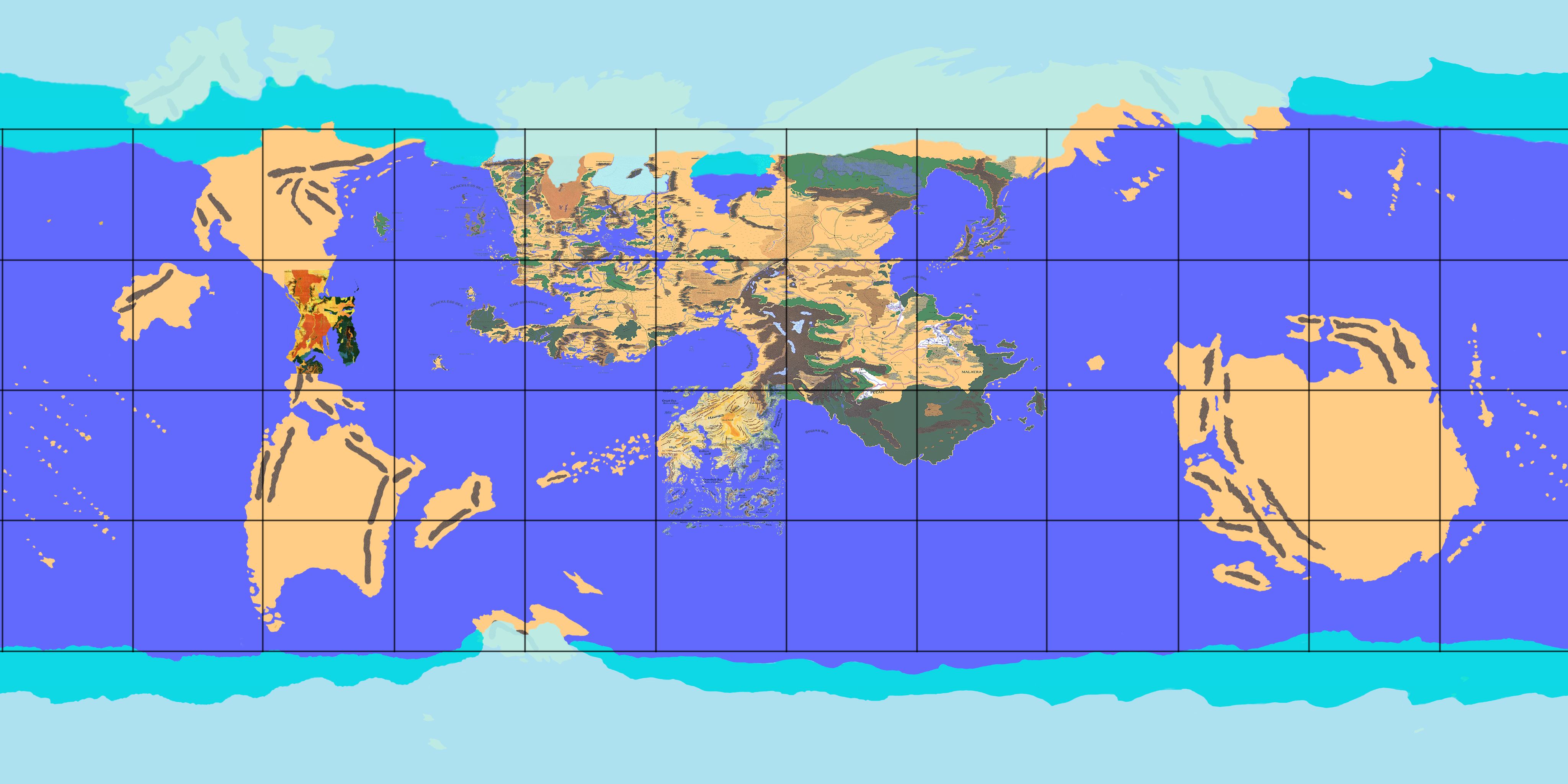
Toril possesses several notable oceans:
- The Trackless Sea lies to the west of Faerûn, separating it from Maztica and the islands of Anchôromé. Marginal seas of this ocean including the Sea of Moving Ice (off the north-west coast), the Sea of Swords (between the coast and the Moonshae Isles) and the Shining Sea (between Calimshan and the Chultan Peninsula). The Bay of Balduran and the Sea of Azul lie off the coast of Maztica. Chult and the island of Nimbral mark the southern end of this ocean.
- The Great Sea lies to the south of Faerûn, separating it from Zakhara to the south and Katashaka to the south-west.
- The Southern Ocean lies to the south of Katashaka, Kara-Tur and Ossë, and encompasses the frozen southern polar region of Toril. Marginal seas of this ocean include the Crowded Sea off the southern coast of Zakhara and the Segara Sea between Zakhara and Kara-Tur.
- The Eastern Sea lies to the east of Kara-Tur, separating it from Ossë and extending north of that enigmatic continent. Marginal seas of the Eastern Sea include the Celestial Sea and the Yellow Sea, off the coast of Kara-Tur.
- The Western Ocean lies to the west of Maztica and Katashaka, separating those continents from Ossë.
- The Endless Ice Sea lies to the north of Faerûn, Kara-Tur and Maztica. The “sea” is actually an immense frozen ice pack extending across the polar regions of Toril and extending onto the landmass of the main supercontinent. The Endless Ice Sea links to the large glacial masses in Faerûn (Reghed Glacier, the High Ice and the Great Glacier of Pelvuria), as well as the Land of the Snow Spirits in northern Kara-Tur. The only notable marginal sea of this ocean is the Great Ice Sea, which cuts southwards to separate northern Faerûn from Kara-Tur.

Notes on World Maps of Toril
Ed Greenwood began writing stories about daring-do as a very young child, inspired by the stories his father read to him from his voluminous library. By around 1967, when he was eight, these stories had coalesced into a – somewhat – consistent setting, an area known as the Sword Coast, where a rotund, brawling merchant called Mirt got into hijinks in cities like Waterdeep and Baldur’s Gate. Greenwood later added elements such as Durnan, a brave warrior who retired to run a tavern in Waterdeep, and the wise sage Elminster. Through the 1970s he expanded the world to encompass the entire continent, which he called Faerûn, and then a wider world, which had no name. In 1978 he converted the Realms for use in an ongoing game of Advanced Dungeons & Dragons and began writing articles for Dragon Magazine, referencing elements of his home setting in his articles.
By 1986 TSR had run into a problem with its existing “traditional” settings, namely that the World of Greyhawk setting had become awkward to use after creator Gary Gygax had been ousted from the company in a boardroom takeover, and their more recent Dragonlance setting had been designed to tell one story and one story alone, and was not suitable for long-term exploration (amongst other things, the signature continent of Ansalon was pretty small and almost every corner of it had been explored in the initial campaign and related novels, not leaving too many unexplored areas for players to tell their own stories). They needed a replacement and TSR editor Jeff Grubb contacted Greenwood to enquire about this setting he’d been quietly establishing in Dragon Magazine over the past seven years. Impressed by the voluminous notes and maps that Greenwood sent (some of which rendered TSR’s offices almost unusable due to their sheer size), TSR bought the setting and fleshed it out for an official release in 1987. Accompanying the initial release were numerous maps of Faerûn and various regions and cities, but no world map. The world at least now had a name courtesy of Jeff Grubb: Toril, later adjusted to “Abeir-toril” to ensure the world name would come first in any encyclopaedia about the setting (Toril remained the common name, however).

A world map did exist, though. In 1982 Greenwood had already created the first global view of his setting, complete with numerous continents beyond Faerûn’s shores and a Mercator projection. However, when TSR bought the Realms, they were primarily interested in the highly-developed Faerûn and not necessarily the other lightly-sketched-out lands. They were also keen to use Greenwood’s world to incorporate other areas already developed in other projects. In short order, the “Desert of Desolation” series of adventures (from 1982-83) were retconned into the setting, in the Dust Desert of Raurin, whilst the “Bloodstone Lands” series (1986-88) was moved into Faerûn, with Grubb and Greenwood rolling back the Great Glacier to make room for the lands of Vaasa and Damara. TSR also rescued a semi-abandoned Celtic setting that had been in the works at the now-defunct TSR UK and recast it as the Moonshae Isles, off Faerûn’s west coast. TSR also made the considerably larger-scaled decision to add the entire continent of Kara-Tur to the setting. Originally developed for the Oriental Adventures sourcebook in 1985 and an accompanying series of adventures, the Asian-themed land was bolted onto the far eastern side of Faerûn.
TSR later added more landmasses to Toril: Maztica appeared across the Trackless Sea to the west in 1991 and Zakhara, the Land of Fate, was added to the south of Faerûn in 1993, as the home of the Al-Qadim campaign setting. Taan, or the Hordelands, the intermediary lands between Faerûn and Kara-Tur, were fleshed out in a new product line in 1990.
Further exploration of Toril was curtailed: products set in Faerûn itself, and thus more immediately accessible in ongoing Forgotten Realms campaigns, seemed to sell better. Also, there were concerns over the degree to which Toril had moved from being an original fantasy setting to a near-carbon-copy of Earth. The lands Ed Greenwood had focused on in his fiction and original D&D campaigns had no real-world analogues: the Sword Coast, the North, Waterdeep, Baldur’s Gate, the Dalelands, Cormyr, Sembia, Thay, the Moonsea and the Great Desert of Anauroch had various inspirations and influences, but they were not 1:1 mapped to real historical settings. When TSR took over and started giving regions of the Realms to other writers to develop, they tended to fall back on copies of existing cultures: the original, much weirder version of Mulhorand became “fantasy Egypt” and Calimshan became “fantasy Arabia.”
The new continents took this problem to new extremes: Kara-Tur was based on Asia to such an extent that in some cases names were barely even changed (“Tabot” and “Koryo” feel a little too-on-the-nose), whilst Maztica was Mesoamerica transplanted to Toril with even historical events unfolding almost exactly as in real life (Captain Cordell of Amn is a carbon copy of Cortés). Taan, the Hordelands, was a riff on Mongolia, although at least they introduced some originality, in particular acknowledging that a Mongol Empire in a world with magic would be a very different kind of polity. Zakhara became Arabia writ large.
The decision after 1994 or so was to refocus on Faerûn and many of the following sourcebooks reinforced explored areas whilst also branching out to less-explored regions, like the Vilhon Reach. Steven Schend, a particularly skilled writer brought into the fold, even performed emergency surgery on Calimshan to remove its more overt Arabia-ness, and later developed the very original, alien underwater world of the Sea of Fallen Stars. Other writers explored the deep history of the Realms through material set in the distant part, like Netheril: Empire of Magic (1996) and Cormanthyr: Empire of Elves (1997).
By this time Greenwood had revised his world map, taking into account the additions of Kara-Tur, Maztica and Zakhara, and given copies to TSR. If TSR wanted to publish a world map, they could easily do so, and they soon had the opportunity.

In 1993, a British company called ProFantasy Software released Campaign Cartographer, a programme to create fantasy maps in a variety of styles. A revised version, Campaign Cartographer 2, was released in 1998 and the most recent version, controversially called Campaign Cartographer 3, in 2006 (although it’s been updated many times since). ProFantasy took out advertising in Dragon Magazine and, apparently due to the high success of the move, became a constant stalwart in the magazine with adverts for not just the core programme but spin-offs like City Designer and Dungeon Designer. TSR contacted ProFantasy with a view to a collaboration, resulting in the release of a more limited but accessible version called Campaign Mapper (included with the Dungeons & Dragons Core Rules 2.0 CD-ROM), and a much bolder project called The Forgotten Realms Interactive Atlas (1999).
Developing the interactive atlas – a noninteractive atlas had been published in 1991, but only covered Faerûn and Kara-Tur – took several years with some very bold ambitions, namely to allow users to zoom in from a map of all of Realmspace to individual rooms in an inn in Waterdeep. This wasn’t exactly Google Toril, though. The maps were derived from all of the maps published so far for the setting in hundreds of campaign settings, adventures, magazine articles, video games and novels. The maps were arranged as hyperlinks, with “jumps” of detail from different scales. For 1999 it was pretty good, although the interface is somewhat janky by modern standards.
For reasons that are not entirely clear, TSR did not provide a map based on Ed Greenwood’s own world map. In fact, it’s not entirely clear where the hitherto unknown continents came from, although the existence of a South America-analogue continent beyond Maztica had been hinted at in products like Gold & Glory (1992) and given the title “the Dark Continent” in a 1999 Dragon Magazine article on languages. Where the very large new continent in the far east of the world came from is also unclear.
Although the Interactive Atlas was both hugely impressive and hugely useful, its canonicity – assumed from being an official TSR product – was in some question due to it not using Greenwood’s original material. In 2001 the Forgotten Realms Campaign Setting, 3rd Edition was released and, despite the core map of Faerûn being bizarrely shrunk by 15% for the new edition (it was thankfully restored to its original size for 5th Edition in 2014), the world map from the Interactive Atlas was canonised in the “Scholar’s View of Abeir-toril” map at the back of the book. The 2004 novel Lady of Poison finally gave the far eastern continent a name, Ossë, and an accompanying Dragon Magazine article on shaman-like magic hinted that it was effectively a merging of Australia, New Zealand and various Polynesian influences.

The continent south of Maztica was referenced further in Serpent Kingdoms (2004) and finally given a name, Katashaka, in The Grand History of the Realms (2007). The island-continent west of Maztica was also given a name, Myrmidune, in the draft version of The Grand History but the name does not appear in the final text, leaving its official status unclear.
In 2008, the Forgotten Realms setting was effectively destroyed in an event known as the Spellplague, with the 4th Edition of the setting developed as a post-apocalyptic setting. Needless to say, this went down like a lead balloon with the fanbase, but it did offer the opportunity to shake up the setting. Greenwood was able to use one of his other continents from his earlier world maps, Laerakond, on the basis that the Spellplague had seen Toril collide with its “shadow world” in another plane, Abeir, and swapped some landmasses with it. Laerakond, initially known as “Returned Abeir” before the other name was adopted, was explored somewhat in the 4th Edition materials. However, with 4th Edition bombing in sales, the decision was made to return Forgotten Realms its late 2nd Edition status quo through an event known as the Second Sundering. The timeline changes were maintained, but Toril was restored to its original appearance and the overlapping lands from Abeir mostly disappeared. The status of Laerakond was unclear, with Greenwood noting in his materials that the continent remained on Toril, but Wizards of the Coast in their official material seeming to indicate it had returned to Abeir.
In fact, Wizards of the Coast took a hands-off approach to expanding the lore of 5th Edition Forgotten Realms. Almost all adventures and sourcebooks focused on the Sword Coast of Faerûn, with even the status of nearby iconic locations like the Dalelands and Tethyr left something of a mystery, let alone other continents. Even the first-ever live-action movie in the setting, Honor Among Thieves, and the mega-successful video game Baldur’s Gate III (both 2023) remain focused on the Sword Coast region.
Whether this position shifts with D&D launches its next major revision in 2024 (an update of 5th Edition rather than a brand new 6th Edition) remains to be seen. If they open up the Forgotten Realms to further exploration, hopefully we’ll get a new world map combining the previously-established material with Ed Greenwood’s original vision, or at least as much as possible.

Changes from the Previous Map
I have removed the very speculative names “Braaklosia” and “Aurune.” These names had doubtful canonicity. I have retained “Myrmidune” as it is moderately more common in fan spaces and appeared in the draft of The Grand History of the Realms, but noted it as a name in-universe of unknown provenance.
I have added Ed Greenwood’s name of Arandron for a continent in Toril’s southern hemisphere, although it is unclear if this landmass is what he was referring to.
The erroneously tiny Malatra Plateau of eastern Kara-Tur (a mistake dating back to 1999’s Interactive Atlas) has been removed and a more lore-accurate Malatra Plateau in south-western Kara-Tur has been added as per the reasoning given in my Kara-Tur map. This is based on Realms cartographic expert Markus Tay’s reasoning from many years ago.
Using the known location of Toril’s equator, I have added the tropics and polar circles, also drawing on Markus Tay’s research on this matter from some years ago.
As well as the main map from The Interactive Atlas, I also consulted several other maps included in the package to add more islands to the Anchôromé region and to the ocean between Ossë and Maztica/Katashaka.
Thank you for reading The Atlas of Ice and Fire. To help me provide better content, please consider contributing to my Patreon page and other funding methods, which will also get you exclusive content before it goes live on my blogs.

Pingback: Nations of the Forgotten Realms: The Full Guide | Atlas of Ice and Fire
What is the sources for the location of Malatra? I am another Realms Cartographer and I also mistakenly placed it in the large southern region of the map. The interactive atlas is the last known to me location of the plateau which is smaller than this location and to the southeast of T’u Lung and Bashan Do.
Here is a link of its Interactive Atlas location which I am sure you have a copy. But this is for other readers.
https://static.wikia.nocookie.net/forgottenrealms/images/e/e9/Malatra.jpg/revision/latest?cb=20220111225219
LikeLike
Malatra is far too small on the FRIA map. If you look at the Living Jungle materials, Malatra is over 1,000 miles east to west, whilst the FRIA placement is more like 400-500 miles.
It’s also in a weird place. The Plateau is supposed to be more remote, but the FRIA placement puts it on the border between Laothan, Kuong and T’u Lung, which are all heavily-populated kingdoms. There’s no way the plateau would be remote and mysterious in that location.
I think also the ProFantasy team got confused by the use of the term “Malatra” in the Kara-Tur boxed set, in which it refers to all the wild lands south of T’u Lung, as opposed to the CRPGA Network when they picked it as the location for their Living Jungle campaign, and Malatra became the name of the specific plateau.
LikeLike
Love your work! Apologies if this is an inane question, but I’m curious what font you use for your map labels on this map and the Ansalon map. Thanks!
LikeLike
ITC Benguiat.
LikeLike